Monday May 18th… Dear Diary. The main purpose of this ongoing blog will be to track United States extreme or record temperatures related to climate change. Any reports I see of ETs will be listed below the main topic of the day. I’ll refer to extreme or record temperatures as ETs (not extraterrestrials).😉
Main Topic: Should “Hurricane Season” Be Year Round?
Dear Diary. This week we are seeing yet another May organized tropical system move through a portion of the Atlantic Basin. As I write this post Tropical Storm Arthur has sustained winds of 50 mph and is bringing low end effects to the Outer Banks area of North Carolina. As Bob Henson indicates in his blog May storms have become much more common during the past ten years:
https://www.wunderground.com/cat6/arthur-strengthens-en-route-to-north-carolina
Yet another early-season named storm
The Atlantic’s hurricane season doesn’t officially start till June 1, but it’s become increasingly common in recent years to get our first named storm in the pre-season period, as is the case with Arthur. Each year since 2015 has had at least one named storm before June 1, and there were a total of eight pre-June named storms in the last decade, as shown below. All of these were tropical storms unless otherwise noted.
2012: Alberto (May) and Beryl (May)
2015: Ana (May); became a subtropical storm, then tropical storm
2016: Alex (January), a hurricane affecting the Azores, and Bonnie (May)
2017: Arlene (April); began as a subtropical depression, then tropical depression and tropical storm
2018: Alberto (May); became a subtropical storm, then tropical storm
2019: Andrea (May), subtropical storm
While all this suggests a trend may be afoot, and that perhaps the start date of hurricane season ought to be moved up, the reality is more complicated. For an excellent roundup of thinking along these lines, see the essay published Friday in Forbes by Weather Geeks podcast host Marshall Shepherd: “Why The June 1st Start Date Of Hurricane Season Is Just Fine.”
……………………………………………………..
Renowned climate scientist Dr. Michael Mann begs to differ, so we have a debate going on between experts:
Personally I’m torned between these arguments while noting trends due to our warming oceans. Increased ocean heat content due to carbon pollution is extending traditional climatological tropical seasons across ocean basins worldwide. Yet, for the Atlantic Basin, so far, these May systems have tended to be weak and basically inconsequential. Down the road though, this may not be the case as we continue to increase our greenhouse effect.
Speaking of very consequential tropical systems, Amphan is poised to pummel the northern Bay of Bengal region. Here is much more on thus Category 5 system from Bob Henson:
Category 5 Amphan to Push Massive Storm Surge Toward Eastern India and Bangladesh
Bob Henson · May 18, 2020, 4:32 AM EDT
Above: GeoColor image of Cyclone Amphan at 0640Z (2:40 am EDT) Monday, May 18, 2020. (RAMMB/CIRA/CSU)
After a spectacular bout of rapid intensification on Sunday, Tropical Cyclone Amphan poses a grave storm-surge threat to the highly vulnerable coastline of the upper Bay of Bengal. The Joint Typhoon Warning Center (JTWC) upgraded Amphan to the equivalent of Category 5 strength at 2 am EDT Monday, with top 1-minute sustained winds estimated at 140 knots (160 mph). Update: As of 11 am EDT Monday, JTWC is rating Amphan’s top winds at 145 knots (165 mph).
On the scale used by the Indian Meteorological Department (IMD), Amphan was upgraded at 3 am EDT Monday to the highest possible level: super cyclonic storm. Only a handful of storms—about one per decade—achieve this level, which corresponds to a three-minute-averaged wind speed of 120 knots (140 mph). Hurricane ratings by the National Hurricane Center and JTWC are based on one-minute averaging, which will yield higher wind speeds for a given storm.
Amphan took advantage of very favorable conditions in the southern Bay of Bengal to strengthen incredibly quickly over the weekend. Drawing on very warm sea surface temperatures of 31°C (88°F), high oceanic heat content, and light wind shear, Amphan bolted from minimal tropical storm strength (35 knots or 40 mph) to Category 5 equivalent strength (140 knots or 160 mph) in just 48 hours—and from minimal hurricane strength (65 knots or 75 mph) to Cat 5 equivalent strength in just 24 hours.
Forecast for Amphan: Some weakening of top winds possible before landfall, but storm surge threat will remain dire
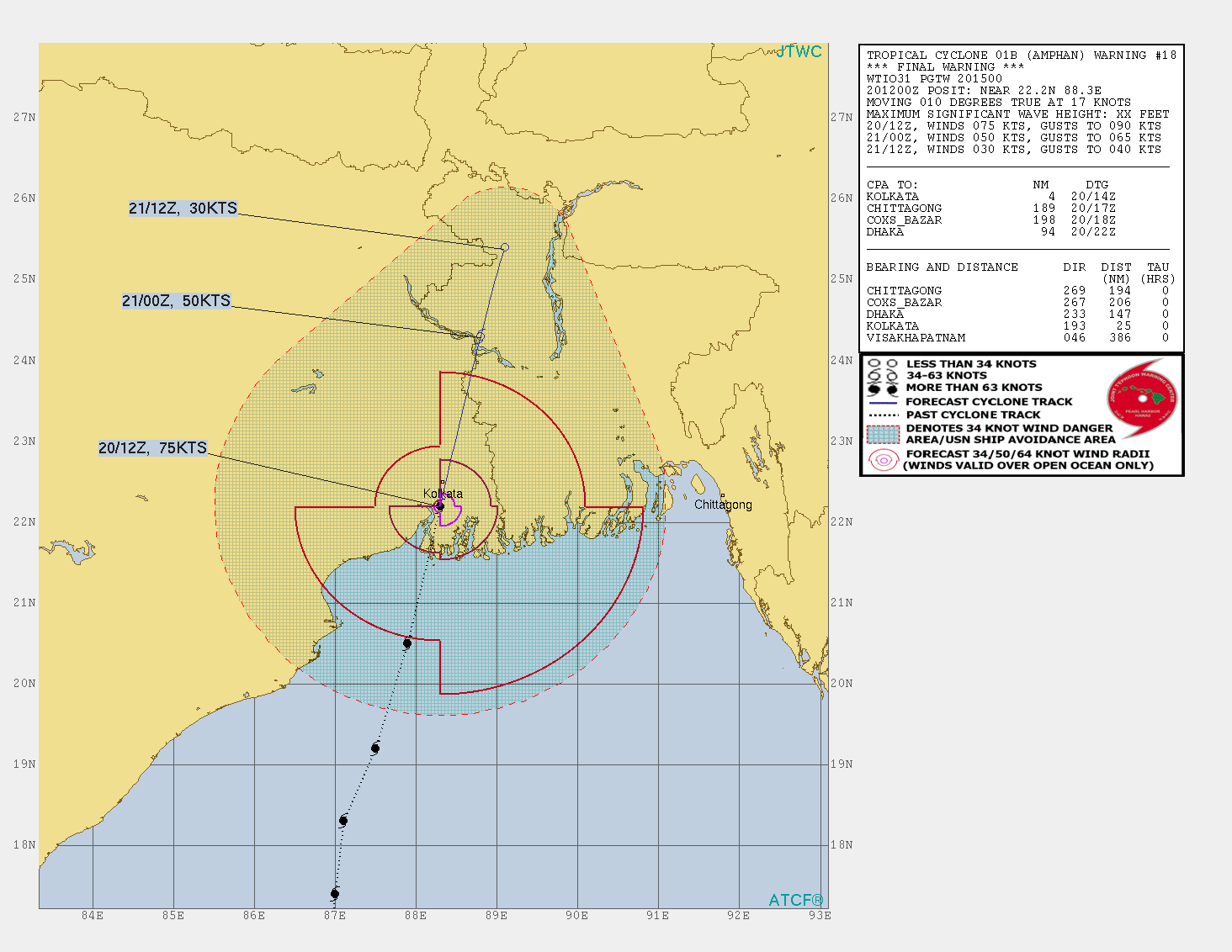
Steering currents are expected to take Amphan on a straightforward track just east of due north. On this course, Amphan will likely make landfall somewhere between Kolkata, India, and Chittagong, Bangladesh, on Wednesday afternoon or evening local time.

Forecast for Amphan from the Joint Typhoon Warning Center as of 15Z (11 am EDT) Monday, May 18, 2020. Amphan is predicted by JTWC to make landfall as a Category 2 or 3 storm within several hours of 12Z Wednesday, which would be 5:30 pm Wednesday in Kolkata, India. (JTWC)
Even as Amphan reached Category 5 strength, there were already signs of a potential eyewall replacement cycle brewing. Such a process would halt Amphan’s strengthening and perhaps weaken it slightly, although it would also tend to expand the cyclone’s wind field. As it moves into the northern Bay of Bengal on Tuesday local time, wind shear will ramp up from around 10 knots to 20-25 knots, and the shear will inject somewhat drier air into the storm.
All these factors imply that Amphan’s top winds may decline gradually in strength before it plows ashore, although perhaps not by as much as the JTWC’s 09Z Monday forecast that Amphan will be a Category 1 storm when it makes landfall. The 00Z Monday run of the high-resolution HWRF model, one of the best models at storm intensity, projects that Amphan will maintain Category 4 strength up through landfall. Update: The 15Z Monday forecast from the JTWC has Amphan approaching the coast as Category 3 strength, as shown above.
The most serious threat posed by Amphan is potentially catastrophic storm surge. Even if Amphan’s top winds weaken, the storm surge threat will remain dire. Amphan is a large cyclone that is already pushing a tremendous amount of water northward into the Bay of Bengal, which exerts a funneling effect on northward-moving cyclones. Any minor weakening of Amphan’s winds from an eyewall replacement cycle would have little immediate effect on mitigating the storm surge threat, which has already been put into motion (literally). There is a great deal of momentum in the water pushed by large, powerful storms even after they weaken, as evidenced by 2008’s Hurricane Ike in Texas and 2012’s Hurricane Sandy in New Jersey and New York.
IMD is warning that a surge of up to 4–5 meters (13–16 feet) is possible over parts of West Bengal, with 3-4 m (10-13 ft) possible into Bangladesh. These values may not yet fully take into account Amphan’s rapid strengthening.
The tragic history of storm surge in the northern Bay of Bengal
Some of the most destructive and deadly cyclones in world history have struck the northern Bay of Bengal. An 1876 cyclone brought the highest known storm surge to Bangladesh—13.0 meters (43 feet). The mighty cyclone killed an estimated 200,000 people. The deadliest storm in world history, the 1970 Bhola Cyclone of 1970, killed an estimated 300,000 – 500,000 when it made landfall in Bangladesh along the Meghna River Estuary near Bhola Island on November 12, 1970. The cyclone brought a storm surge estimated at 10.4 meters (34 feet) to the coast.
Just last year, the Bay of Bengal experienced an intense May cyclone: Category 4 Tropical Cyclone Fani, which made landfall in eastern India in the state of Odisha on May 2 with sustained winds of 155 mph. Fani killed 89 people and did $8.1 billion in damage in India and Bangladesh, according to insurance broker Aon, making it one of the top-five costliest Indian cyclones on record. Fani’s landfall to the western side of the bay meant that the storm surge just to the right of the center was less than a landfall at the top of the bay would have produced.

Extremely Severe Cyclonic Storm Fani approaching India at peak intensity on May 2, 2019. At that time, Fani had 1-minute average sustained winds of up to 155 mph (250 km/h). (NASA Worldview)
Prior to Fani, the most recent major tropical cyclone to hit India was the 1999 Odisha Cyclone, which hit Northeast India in the Indian state of Odisha (formerly called Orissa) near the city of Bhubaneswar as a Category 4 storm with 155-mph winds on October 29, 1999. The mighty storm drove a storm surge of 26 feet (8 meters) onto the coast, then stalled just inland, dumping torrential rains. The catastrophe killed 9,658 people and left $2.5 billion in damage (1999 dollars), India’s most expensive and fourth deadliest tropical cyclone in the past 100 years.
Warning systems have been greatly improved in India and Bangladesh over the 20 years since the Odisha cyclone. However, the region’s geography and high population means it is still exceptionally vulnerable, and Amphar will need to be taken seriously by all concerned. The novel coronavirus pandemic will no doubt complicate evacuation and sheltering in myriad ways.
Tropical Storm Arthur to pass near the Outer Banks of North Carolina
A tropical storm warning remains in effect for eastern North Carolina ahead of Tropical Storm Arthur, which is on track to move just east of the Outer Banks later on Monday. Impacts on the North Carolina coast should be minimal, and computer models have come into better agreement on an eastward bend that will take Arthur out to sea by Tuesday. For the latest forecast, see the frequently updated weather.com article.
Dr. Jeff Masters contributed to this post.
The Weather Company’s primary journalistic mission is to report on breaking weather news, the environment and the importance of science to our lives. This story does not necessarily represent the position of our parent company, IBM.

Bob Henson
Bob Henson is a meteorologist and writer at weather.com, where he co-produces the Category 6 news site at Weather Underground. He spent many years at the National Center for Atmospheric Research and is the author of “The Thinking Person’s Guide to Climate Change” and “Weather on the Air: A History of Broadcast Meteorology.”
My “Scooby Sense” is telling me that this hurricane season in the Atlantic will be active and awful due to higher than average sea surface temperatures and low wind shear. Stay tubed through at least October as we delve into each significant tropical system on this blog.
An update:
Here is more climate and weather news from Monday:
(As usual, this will be a fluid post in which more information gets added during the day as it crosses my radar, crediting all who have put it on-line. Items will be archived on this site for posterity. In most instances click on the pictures of each tweet to see each article. The most noteworthy items will be listed first.)
Now here are some of today’s articles and notes on the horrid COVID-19 pandemic:
(As usual, the most noteworthy items will be listed first.)
(If you like these posts and my work please contribute via the PayPal widget, which has recently been added to this site. Thanks in advance for any support.)
Guy Walton “The Climate Guy”