Wednesday June 5th… Dear Diary. The main purpose of this ongoing post will be to track United States extreme or record temperatures related to climate change. Any reports I see of ETs will be listed below the main topic of the day. I’ll refer to extreme or record temperatures as ETs (not extraterrestrials)😉
U.S. Extreme Flooding Update
Sometimes in the world of weather forecasting, despite ever better models. a forecast can go awry, and this time around we have the case for more significant flooding in the Midwest. Apparently the remnants of 91L, which didn’t turn into a tropical depression or storm in the western Gulf, will combine with a cold core system to produce a low pressure system that will move more east than north into the Southeast, taking the potential of heavy rain with it. So, it looks like the southern Plains, including Oklahoma, and much of the Mid-Mississippi Valley is off the hook for widespread flooding rain. A “Gulf Runner” would inhibit the flow of moisture north into the Midwest, thankfully. Here is the forecast from a couple of days ago:
(Notice that the quantitative precipitation forecast for the Gulf Coast had relatively little rainfall.)
My neck of the woods from Georgia southward into Florida is in need of rain, which is apparently coming, but will there be too much falling at once? It now looks like we will see a weak low pressure system oozing slowly through the Gulf coastal area producing folding rains there, perhaps measured in feet, which would be historic. Interior portions of the Southeast will get a substantial dowsing, as well.
Here are outlooks from the Weather Prediction Center for the next two days:
I’m thinking that the WPC’s day two outlook for flooding into Oklahoma is too far west. We will see.
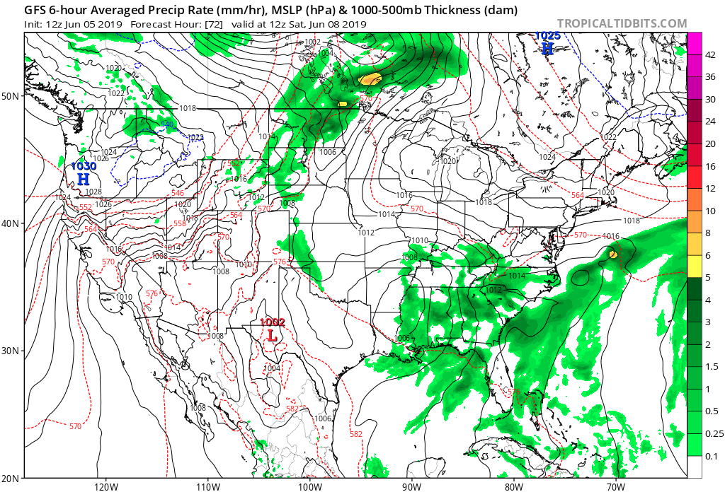
Here is our low pressure system affecting the Southeast by Saturday:
All of this is great news for the Midwest, but some area near the Gulf Coast, or further north from Mississippi through Georgia into the Carolinas, is going to be in for a proverbial world of hurt over the next week. Climate change is definitely making concentrated areas of extraordinary rainfall just ordinary. This should be another of those situations.
………………………………………………………………………………………………..
Here is some more climate and weather news and notes from Wednesday:
(As usual, this will be a fluid post in which more information gets added during the day as it crosses my radar, crediting all who have put it on-line. Items will be archived on this site for posterity. In most instances click on the pictures of each tweet to see each article.)
(If you like these posts and my work please contribute via the PayPal widget, which has recently been added to this site. Thanks in advance for any support.)
Guy Walton…The Climate Guy