Monday December 17th… Dear Diary. The main purpose of this ongoing post will be to track United States extreme or record temperatures related to climate change. Any reports I see of ETs will be listed below the main topic of the day. I’ll refer to extreme or record temperatures as ETs (not extraterrestrials)😊.
Mild And Stormy Weather Ahead For U.S. Before Christmas
A few days ago I alerted my readers that the “January Thaw” would come early to the United States:
So how is that forecast doing? The best way to tell is by looking at snow cover from the 12th when colder than average temperatures were occurring for most locations east of the Rockies and now, the 17th:
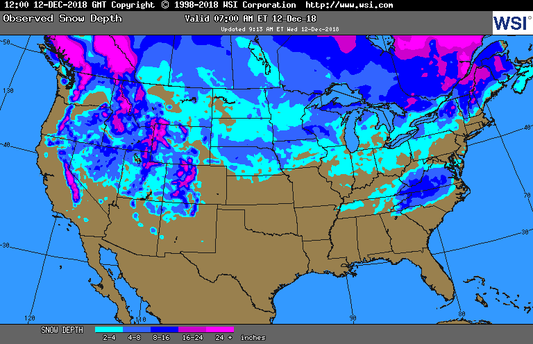

In the wake of this past weekend's Texas->NC/VA snowstorm, almost half (46.7%) of the US was covered in snow. That number is now down to about 1/3 of the US (34.2%), and the upcoming pattern promises further reductions from the Rockies eastward (maps from https://t.co/w1ywjdIRrL) pic.twitter.com/lDP8DcgAVQ
— Radiant Solutions | Weather Desk (@Radiant_Weather) December 13, 2018
Carolina and Virginia snow cover from the southern storm, The Weather Channel’s last named winter storm, Diego, as would be expected even in a colder climate, has melted. Much of the snow cover has melted in the traditional chilly Midwest. Only New England has seen an increase. Snow cover should be on the increase in the Inter Mountain West as that area of the country continues to get slammed with winter storms, which is typical for most Decembers.
Aspen, Colorado, is just one of about a dozen locations boasting a 100% historical probability of seeing a #WhiteChristmas https://t.co/K5CiqDTw54 pic.twitter.com/O32MHFFukn
— NOAA NCEI Climate (@NOAANCEIclimate) December 17, 2018
Lower elevations of the West will continue to be mild, and most areas east of the Rockies on Tuesday will see well above average temperatures, particularly across the northern tier of states:
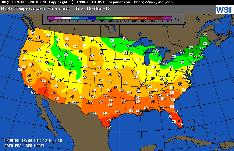
It will be dangerous to do any traditional ice fishing or ice skating from the Dakotas eastward through Minnesota and the Great Lakes area. Only New England will feel like mid December. The expected mild pattern for the northern tier of states due to the advent of El Nino looks like it has already kicked in.
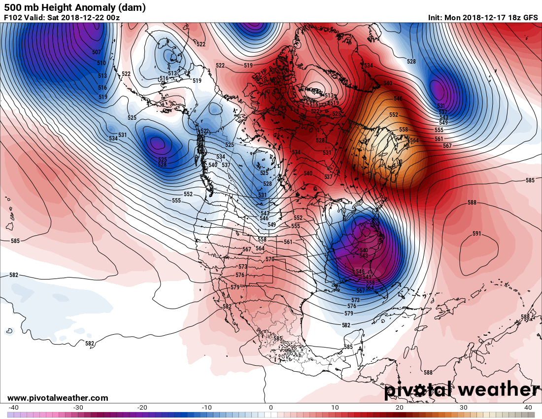
Later this week another strong gyre will start to spin aloft across the South and Mid-Atlantic, but yet again there won’t be enough cold air to generate much snow at the surface:
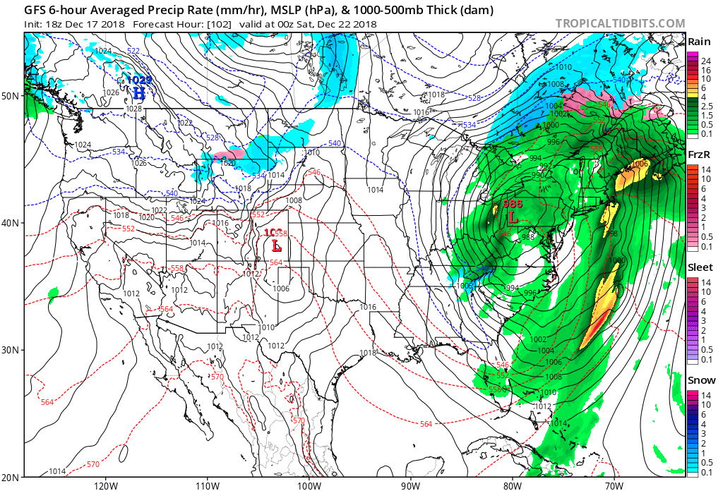
What catches my eye here by Friday is the distinct lack of snow forecast by this model from the Great Lakes through the Appalachians northeast all the way through New England. Snow this time of the year in association with such a storm should be falling west of the surface low and in New England. Mother Nature had better get her act together in a hurry thereafter, or a lot of folks wishing for a White Christmas will be very disappointed. In any case we should see a lot of rain and wind late in the week as people start to travel for the holidays. Air travel in the East will probably be hampered. Localized flooding may be an issue in the South and East.
Here's a look at those higher temperatures were expecting. A 10 day forecast just showing 12 hour daytime temperatures pic.twitter.com/XBWnhVOk89
— Scott Cook (@scook2214) December 18, 2018
This mild weather pattern would have been possible in the colder decades of the 1960s and 1970s, but highly unlikely. Climate change can be very sneaky for us humans given our relatively short lifespans. Children, if you live in the Midwest or Northeast ask your grandparents about cold and snowy weather leading up to Christmas, and you should get an earful about how times have changed. I do expect another few cold patterns to occur before spring, but am uncertain as to how brief or how many, of course. Anomalous mild to warm weather during the winter is a signal of global warming, indeed, and the weather this coming week in the Midwest and Northeast will be yet another sign.
………………………………………………………
Here are more climate and weather stories from Monday:
(As usual, this will be a fluid post in which more information gets added during the day as it crosses my radar, crediting all who have put it on-line. Items will be archived on this site for posterity.)
Remember all that nonsense about "It stopped warming in 1998"….All of that was people looking at an El-Nino maxed year and not understanding long-term trends…. https://t.co/9RI2iQKli8
— Marshall Shepherd (@DrShepherd2013) December 17, 2018
The Permafrost Line Has Moved 80 Miles North In 50 Years In Parts of Canada
The Sahara Desert Has Gotten 10% Bigger Since 1920
The 100th Meridian Has Shifted 140 Miles East#ClimateChange #ActOnClimate https://t.co/zu9xO1dAc7
— Paul Dawson on Climate Change (@PaulEDawson) December 17, 2018
Do you have a question about climate science, impacts, solution and communication? Want to see what other people are asking, and upvote your favs? Ask here, and I'll answer tomorrow! https://t.co/0GIr06KRQa
— Katharine Hayhoe (@KHayhoe) December 17, 2018
Scientists who revealed cause of 'great dying' extinction call for action on climate change https://t.co/iP3MA6sZvN
— Scott Cook (@scook2214) December 17, 2018
While this continues, nobody can claim that we have seriously tried to get out of fossil fuels! #globalwarming pic.twitter.com/TMmwk2ciCo
— Stefan Rahmstorf (@rahmstorf) December 17, 2018
(If you like these posts and my work please contribute via the PayPal widget, which has recently been added to this site. Thanks in advance for any support.)
The Climate Guy