Thursday October 11th… Dear Diary. The main purpose of this ongoing post will be to track United States extreme or record temperatures related to climate change. Any reports I see of ETs will be listed below the main topic of the day. I’ll refer to extreme or record temperatures as ETs (not extraterrestrials)😊. Here is today’s main climate change related topic:
Tracking Michael Day Five
Today will be the last day in which the main topic is Michael. As of this writing Michael is a tropical storm with maximum sustained winds of 50 mph moving into North Carolina, a figment of its former self, but affecting areas hard hit by Florence only a couple of weeks ago. Just like with Florence it’s time for me to drag out my climate change check list to see if Michael has any aspects that researchers can identify for carbon pollution attribution:
1) Record strength per relatively high latitude (For example, Florence attained a high wind speed at a relatively high latitude for September in the Atlantic Basin.)
2) Record or near record low pressure and corresponding record high sustained wind speed (Wilma from 2005 holds that record over the Atlantic Basin at 882 millibars.)
3) Longevity of maintaining a relatively high wind speed. (Irma set some records for this over the central Atlantic last year.)
4) Record rainfall after landfall (Harvey set many records for totals last year.)
5) Stalling, becoming trapped underneath a warm ridge either before or after landfall. (Harvey was the poster child for this effect.)
6) Record or near record rapid intensification
7) Record late or early season tropical cyclones for any given ocean basin
8) Record length of time a tropical system is able to maintain depression status or higher once moving inland
9) Forming over “odd” locations of an ocean basin not traditionally seeing tropical development
10) Seeing numerous simultaneous systems over the world’s oceans
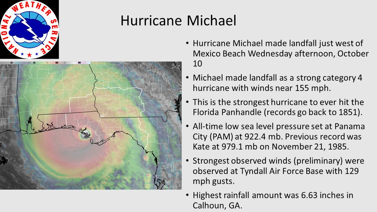
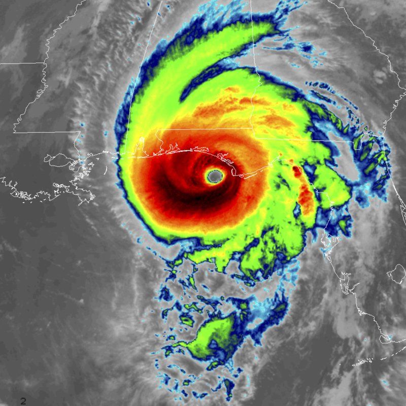
Well let’s see. Michael attained winds of 155 mph and a pressure of 919 millibars before landfall, so #2 might apply, especially considering high Gulf SSTs and very warm air aloft over the eastern U.S. for the system to feed on.
#6 is a definite thing to look at. Michael was no more than a depression on Sunday near the Yucatan Peninsula and became a near CAT 5 hurricane on Wednesday undergoing what most experts considered as surprising intensification.
It was a quick turnaround for #Michael. From tropical storm to Category 4 hurricane back to a tropical storm in just three days. Long days if you were in the path of Michael's destruction. We at the @weatherchannel have been with you through the whole thing. pic.twitter.com/fOBeztXz4K
— Shane Brown (@SDBrownWX) October 11, 2018
#7 may apply since a CAT 4 storm hitting the Florida Panhandle as late as October was unprecedented. In my opinion Michael had more climate change connections than either Maria or even Katrina.
Special notes:

Sadly, we now have 6 confirmed fatalities due to #Michael, all inland. 4 in Gadsden County, FL (NW of Tallahassee), one in Seminole County in SW Georgia, and one north of Charlotte in Iredell County, NC. Most known to be due to wind knocking down trees or structures onto victims.

Here are some stats on the historic Hurricane Michael.

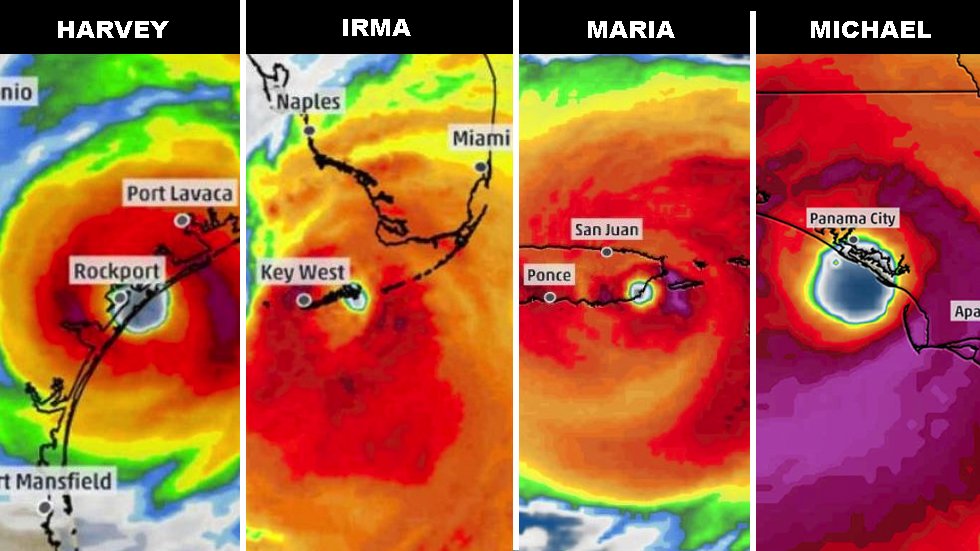
The four Category 4 U.S. #hurricane landfalls in less than 14 months. #HurricaneMichael #Michael

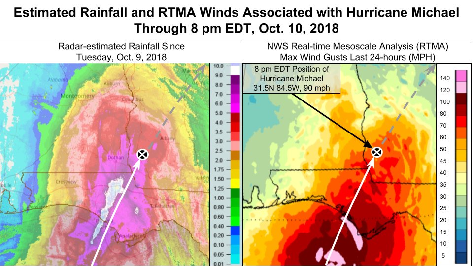
Here is a plot of Hurricane #Michael‘s track in relation to the axis of heaviest radar-estimated rainfall (left panel ) as well as locations of highest wind gusts according to the NWS Real-time Mesoscale Analysis data set (right panel).
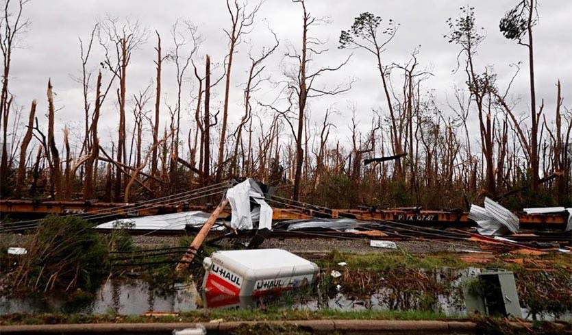
The following are more linked news articles, social media messages, and devastating images from the day after Michael hit the Florida Panhandle. As usual the newest items will appear at the top of the post. My heart aches for people and families left to pick up the pieces from this historic hurricane:
(As usual, this will be a fluid post in which more information gets added during the day as it crosses my radar, crediting all who have put it on-line. Items will be archived on this site for posterity.)
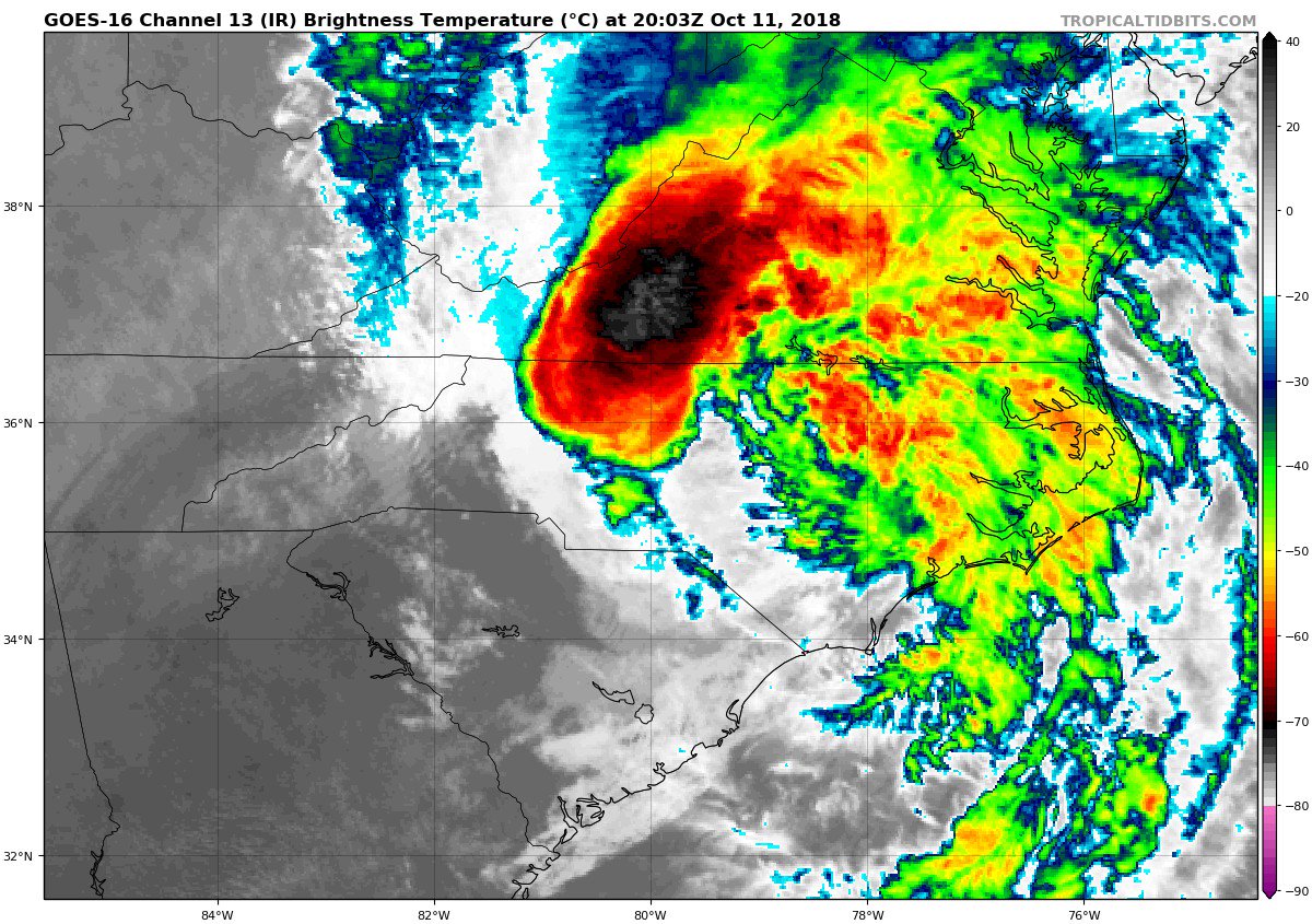
Dear Diary: This afternoon Michael is not done by a long shot:
Winds are increasing rapidly (growing blue area on radar) on the backside of #Michael– be prepared for damaging winds in central NC and VA, including the Raleigh area shortly. pic.twitter.com/Meexgx9kAp
— Eric Blake 🌀 (@EricBlake12) October 11, 2018
Michael just won't quit. This actually looks like a developing storm over the Ocean. pic.twitter.com/cpkWue0xV8
— Scott Cook (@scook2214) October 11, 2018

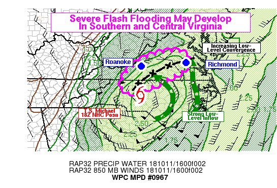
Oh my! Thunderstorms (convection) is blowing up fast along the spine of the central Appalachians frim Michael leading to flash flood emergencies in Virginia this afternoon.

From @NWSWPC
“Severe, life-threatening flash flooding with deeper inundation and numerous impacted roads is growing increasingly likely in portions of southwest and south-central Virginia, where rain rates may exceed 2-3 in/hr at times. ”

People often ask me why don’t you have any wind gauges on the ground to support the NHC estimate- this is why! Most of the time they are knocked out or the power is gone, effectively terminating the station

Tornadoes will threaten NC/VA this afternoon before TS #Michael reemerges in the open Atlantic. Meanwhile, some residents of the Florida Panhandle are dealing with mind-boggling destruction https://bit.ly/2RFJGoa
Aerial view of devastation at #MexicoBeach, Fl caused by #HurricaneMichael
Courtesy LSM/Brandon Clement pic.twitter.com/hqHTdkOz2E
— ABC 33/40 News (@abc3340) October 11, 2018
Before v. After … homes swept off their foundations in Mexico Beach #HurricaneMichael #flwx #gawx pic.twitter.com/S7mWnh9hae
— Greg Postel (@GregPostel) October 11, 2018
These trees near Tyndall AFB look like they've been snapped like a bunch of matchsticks. Incredible. pic.twitter.com/PlNDdwwArd
— Matt Reagan (@ReaganMatt) October 11, 2018

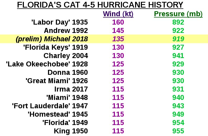
And now that #HurricaneMichael has made landfall, here is where it sits in Florida’s hurricane history…

Unusually warm waters in the Gulf of Mexico — a signal of #climatechange — supercharged Hurricane Michael https://buff.ly/2C9KPPs via @AP @borenbears

Drone video of devastation left in Mexico Beach http://bit.ly/2yi39TP

Tyndall Air Force Base suffered extreme damage from Hurricane #Michael as it came ashore. Nearly every structure on base suffered roofing damage according to the base commander. #flwx #tropics pic.twitter.com/9WeXTwMSu4
— Zach Covey (@ZachWPDE) October 11, 2018

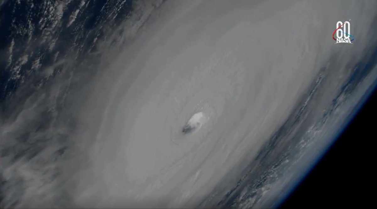
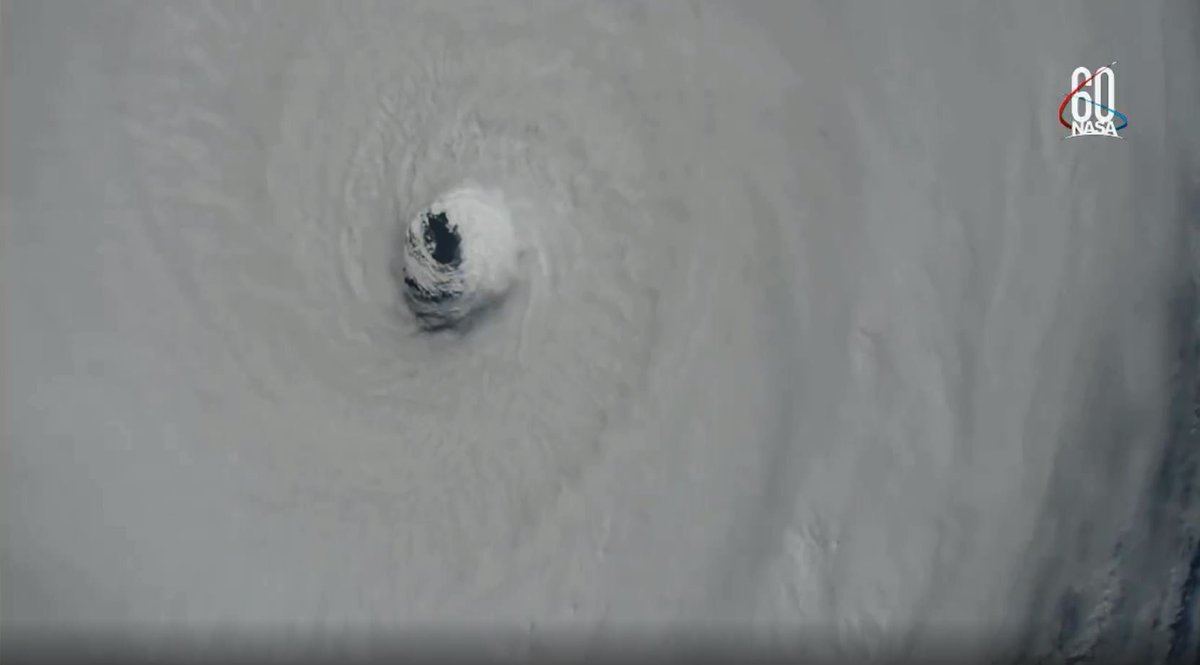
The @Space_Station just made a pass over #HurricaneMichael within the last minute. Look at these stunning views. #Michael #FLwx


(If you like these posts and my work please contribute via the PayPal widget, which has recently been added to this site. Thanks in advance for any support.)
Chaleur tardive jusqu'à samedi inclus, qui sera la journée la plus chaude avec des records décadaires par endroits. Possibles 30°C localisés en Aquitaine et 27°C sur le Benelux !
Net rafraîchissement dimanche.animation : Tx WRF-NMM de ce jeudi 11 au dimanche 14/10 @meteociel pic.twitter.com/tLkLdN95k6
— Etienne Kapikian (@EKMeteo) October 11, 2018
The Climate Guy