Wednesday May 30th… Dear Diary. The main purpose of this ongoing post will be to track United States extreme or record temperatures related to climate change. Any reports I see of ETs will be listed below the main topic of the day. I’ll refer to extreme or record temperatures as ETs (not extraterrestrials)😊. Here is today’s main climate change related topic:
Warmest May On Record For United States
Yesterday I saw this information leading me to believe that May 2018 will be the warmest May in recorded history for the lower 48 states:
For this data set all monthly ratios of > 10 to 1 DHMX to DLMN or > 10 to 1 DLMN to DHMX are in bold type. The rankings are for the lower 48 states with the warmest ranking since 1895 of average temperatures being 124 and 1 being the coldest as of 2018. Blue colors represent cold months and red warm. Those months with counts close to a 1 to 1 ratio of highs to lows are colored black.
May 2018 stats are in bold type since the ratio of DHMX to DLMN is above 10 to 1. Thank goodness we are seeing this 10 to 1 ratio happen in May instead of from June-August when temperatures typically reach life threatening levels, although there are strong signs that June 2018 will start out hot across the Plains.
Note that as of 5/28 there have only been 119 reports of record lows reported across the country (including Hawaii and Alaska). When we go back to May 1934 this is what we see:

Here we see a far greater total of reports, 7461 for May 1934, than the 3070 for May 2018. It’s worth noting that there were substantially fewer stations reporting in 1934 than the present day. We should see roughly 500-750 more reports coming into the NCEI database for May 2018 before data is complete looking at trends. We may eventually only have half the number of DHMXs for May 2018 than got tallied for May 1934, which gives me pause to state that emphatically May 2018 will be the warmest May in record. The one big, warm statistic that stands out, however, is that only 119 reports have come in so far for May 2018 vs 901 for May 1934 again keeping in mind that there were far fewer viable reporting stations in the mid 1930s. You have to go all the way back to May 1922 to find a May with fewer DLMN reports for any month prior to May 2018:

The count of 119 DLMXs for May 2018 stands out even more since I’ve found that prior to 1923 record counts plummet in the U.S. due to the lack of viable stations. Evidently many came in line in 1923 after qualifying for that 30 year continuous service requirement. Despite the warm conditions in May 1934 over 900 daily record lows were either tied or broken vs the only 119 this May.
So, we will see if Victor Murphy’s claim for May 2018 holds up. I may add more information pertaining to Murphy’s warm claim in the next couple of days.
Statistically were we due for a hot May this decade for the CONUS? I think so looking at monthly ratios through April 2018:
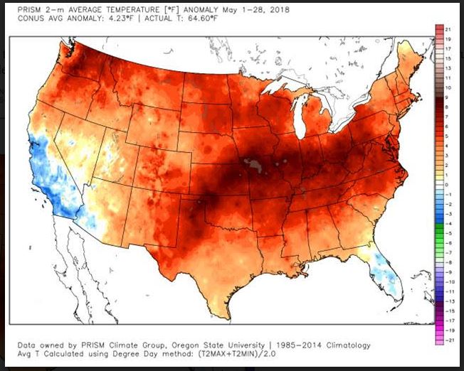
Speaking of warm May 2018 events meteorologists are dumbfounded how well structurally Alberto has held up as it moves almost due north from the Gulf if Mexico into the Great Lakes:
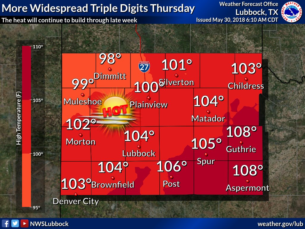
For the last day of May 2018 it will continue to be plenty toasty across most of the U.S. with some dangerous levels in Texas. And oh yes, it may get to 90F in Detroit in the wake of Alberto:
Tomorrow we will take a look at some medium range models to see how long the heat will persist going into June.
(If you like these posts and my work please contribute via the PayPal widget, which has recently been added to this site. Thanks in advance for any support.)
The Climate Guy


 Michael VentriceVerified account@MJVentrice
 NWS LubbockVerified account@NWSLubbock