Friday Evening Updates…
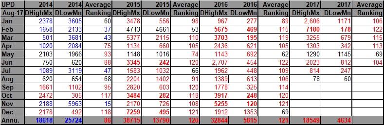
Dear diary. Most of this afternoon I have been processing NCEI data that updated through 8/2/17. Indeed, July 2017 came in at a ratio of approximately 4-1 of record daily high maxes to daily low minimums, and July was the 32nd consecutive month since November 2014 of more daily high records than lows… an astounding figure when looking at the totality of the data since 1920. Here is what we see since 2014:
August 2017 may break “The Streak” looking at a negative anomaly at 500 millibars that will persist over the Midwest for a good chunk of the month. Records coming in from heat wave #5 in the West have given the “warm team” a statistical head start, though.
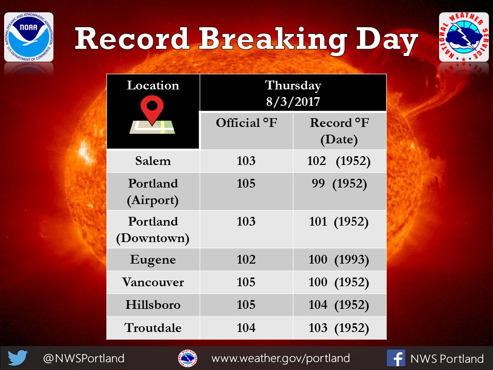
I knew that I’d eventually find a good record graphic. This is from NWS Portland. (If you are reading this NWS Seattle get with the program and make something similar.🙂):
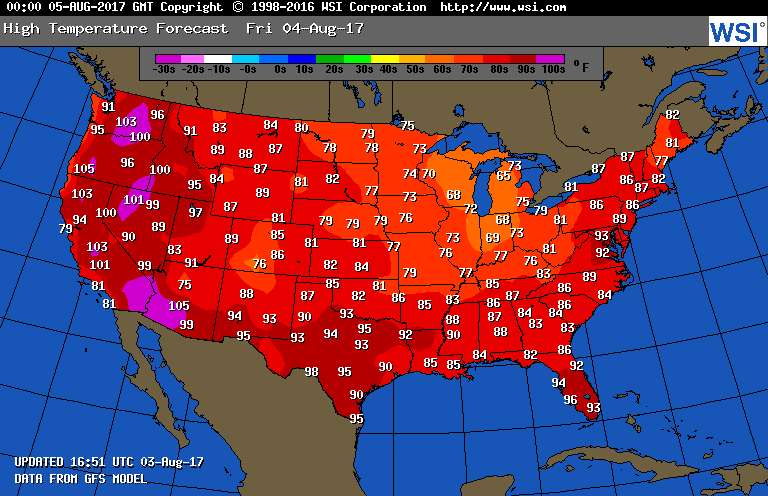
For a change tonight here is a different graphic depicting Friday’s national highs:
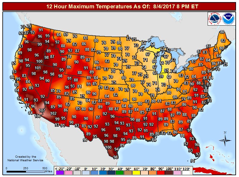
The highest maximum temperature was at the nation’s heat capital Death Valley at 112F. Except in the smoky Pacific Northwest, temperatures were quite palatable on Friday.
I may add more relevant tidbits to this post later this evening.
The Climate Guy
Friday August 4th…
Dear diary. Here is Thursday’s maximum temperature chart:
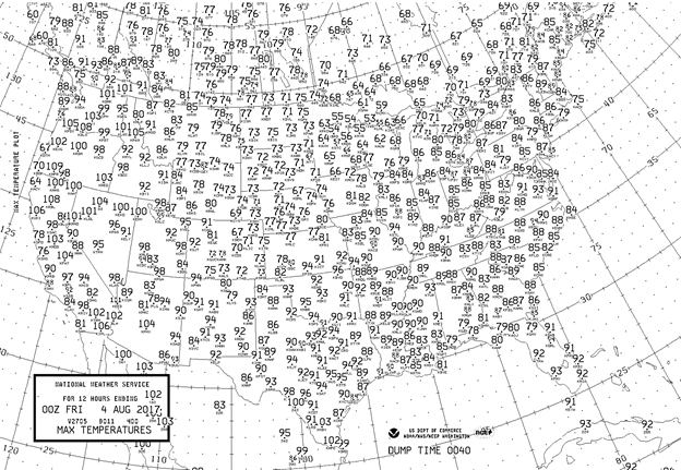
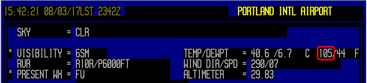
The Pacific Northwest heat wave reached its zenith yesterday. Due to smoke Seattle didn’t get above 94F but did establish a new daily record. Portland sheltered at 105F, which was their hottest temperature since 2009, but not all-time record:
Bob Henson writing for the Category 6 Blog of Weather Underground has more on the smoky heat in the Pacific Northwest as well as a terrible heat wave gripping southern Europe in international news here:
https://www.wunderground.com/cat6/roasting-and-gasping-pac-nw-all-time-record-heat-southeast-europe
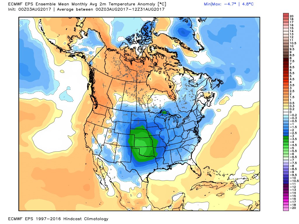
The Midwest continued to see a cooling trend on Thursday. Very chilly maxes for early August in the 50’s can be seen on the max chart in Minnesota and Wisconsin. Most of the nation will see a big break from summer heat through at least the 15th of this month if not beyond:(European model image from Ryan Maue)
I would expect that there will be some record lows coming from the Midwest this week. We will see, as some folks claim, if “summer is over”.
Ironically, carbon pollution related warmth at high latitudes in western and near Greenland will force the jet stream south during the first half of August leading to below average temperatures across most of the CONUS:
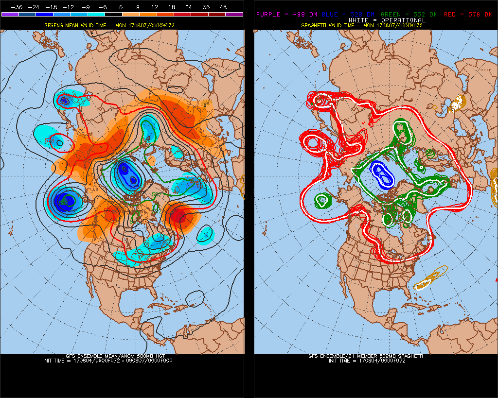
These “blocks” as they are called, meteorologically, during this forecast synoptic pattern will be orienting themselves at longitudes and longitudes that have been rare in the past three years, but common from 2013-2014 when the U.S. experienced intrusions by the “polar vortex”, leading to a lot of cold weather and that prolonged drought in California.
Here is the model profile for U.S. temperatures on Saturday:
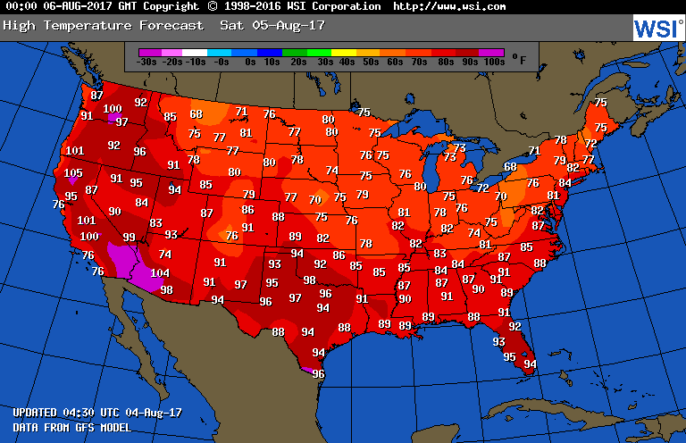
Though hot, most locations in the West will be below record levels. East of the Rockies this chart looks more typical of September than August.
I’ll be adding to this post throughout the day as related items cross my radar.
The Climate Guy
Thursday August 3rd…
Dear diary. My main task the next couple of days will be reporting on the heat from the Pacific Northwest. Here are the current state of NWS advisories:
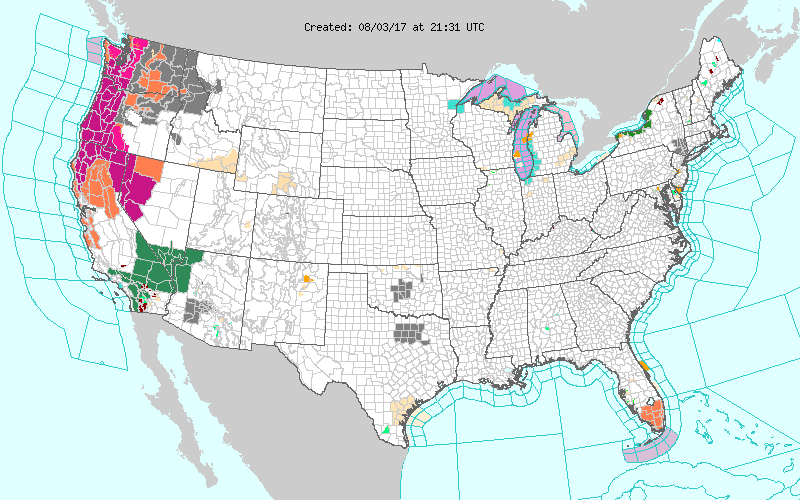
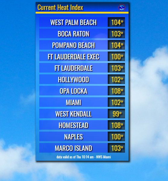
Before we get to the West notice that heat advisories have been posted in south Florida. After only a brief break Miami is experiencing above average heat once more. Here are some heat index values that were reported from south Florida earlier today:
Another eye opening heat streak is occurring at Red Bluff CA (Chart from Rob Ellington):
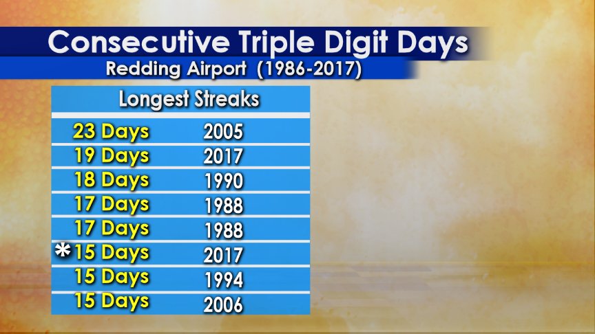
Note that the current streak of *15 days is occurring after the last set of 19 days was broken, so we have two extremely hot long periods for Red Bluff this season.
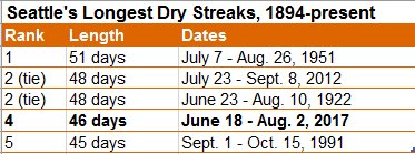
Dry weather and heat, obviously, go hand in hand. I’m now watching this streak at Seattle:
Tomorrow our western heat wave should be waning considerably along the immediate west coastal area, which is great news:
While still above 90F both Portland and Seattle will not be experiencing heat that won’t be nearly as dangerous as that of Wednesday and Thursday.
I will be taking a break from blogging tonight, and will be reporting on more heat numbers from the West Friday.
To see all 2017 Heat Diary entries click:
https://guyonclimate.com/category/heatdiary2017/
The Climate Guy