Sunday February 25th… Dear Diary. The main purpose of this ongoing post will be to track United States extreme or record temperatures related to climate change. Any reports I see of ETs will be listed below the main topic of the day. I’ll refer to extreme temperatures as ETs (not extraterrestrials)😊. Here is today’s main climate change related topic: The Sick Vortex
(If you like these posts and my work please contribute via the PayPal widget, which has recently been added to this site. Since I am a paraplegic I can definitely use any funds for medical expenses. Thanks in advance for any support.)
Sometimes I don’t see much strange weather that can be tied to climate change for a few weeks. This has not been one of those times during February 2018. We’ve recently seen a mega ridge build across the East and South in the United States with many warm and wet ramifications east of the Rockies, which I’ve been blogging on the last five days. Now on social media climate scientists have let all know about exceptional warmth building towards the North Pole is causing the jet stream to kink in “weird” ways not fitting with historic climatology. What we are beginning to see this decade during the winter is what I’ll term the “Sick Vortex.”
Back in the winter of 2013 the words “polar vortex” began to be bandied about in reference to colder than average intrusions of air. The winter of 2013 was a cold one for the United States. Social media keyed on what really were extensions, or lobes of the circumpolar vortex digging the jet into the continental United States ushering in arctic air. The polar vortex, which has been around in the meteorological lexicon for decades, is an area of low pressure generally located above each of the planet’s polar regions containing a mass of extremely cold air. The colder the air mass from the surface up to the 500 millibar level, or about half way up through the atmosphere, the stronger the vortex and its extensions ushering cold air southward towards lower latitudes. Now we are seeing more frequent intrusions of warm air northward to the Arctic, which I contend is due to climate change. Here is a NASA article thoroughly showing how warming intrusions in the Arctic are becoming more frequent:
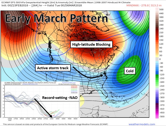
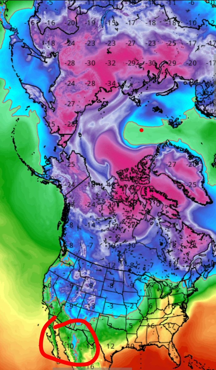
This week the vortex is looking very strange to me as noted on this Penn State model ensemble chart:

On the chart valid for Friday 3/2/18 we see a big spike of red, or above average warmth, nosing from the Aleutians in Alaska northward towards the pole. The strongest warm anomaly, as noted be a purple blotch over Greenland, is a whopper and happens to be the strongest forecast negative North Atlantic Oscillation on record…..very eye opening from a climatological perspective going into early March:

Underlying graphic via @RyanMaue and http://weathermodels.com
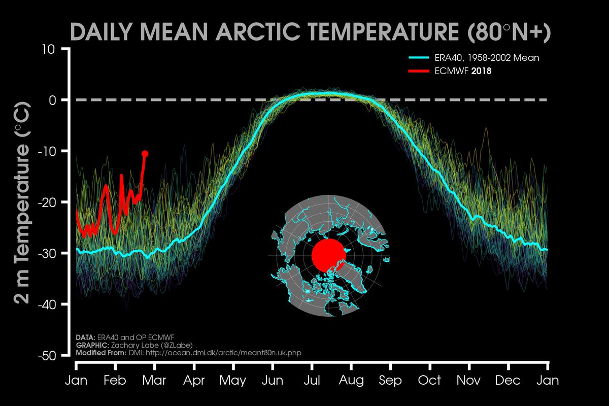
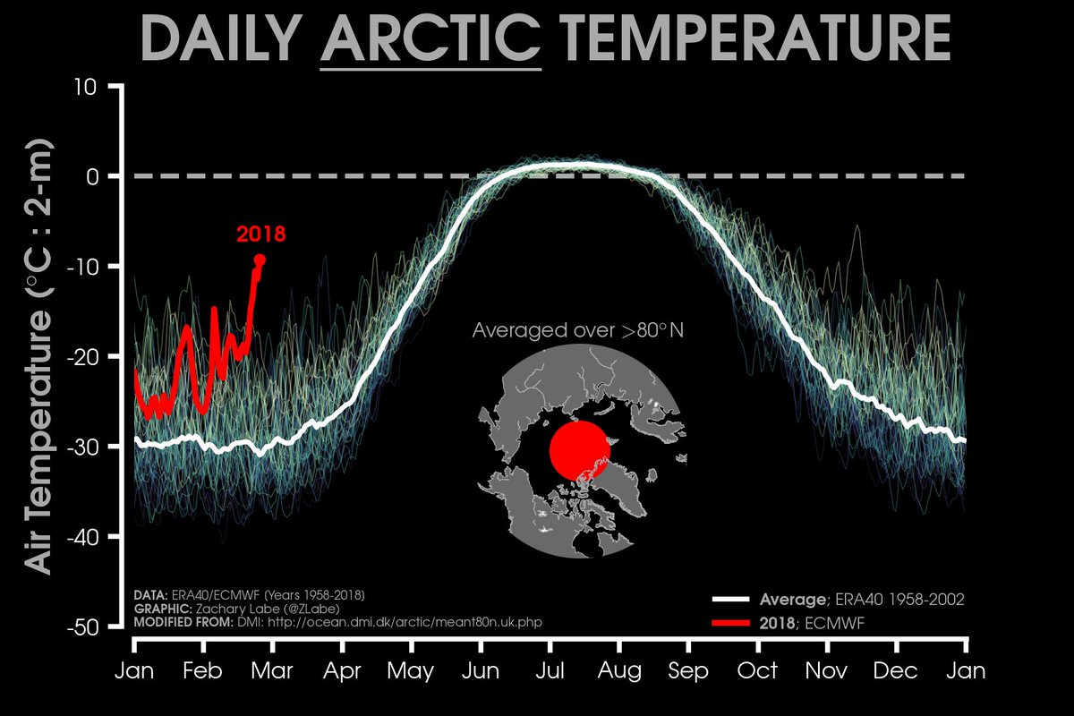
During late February many have noted extreme warmth heading poleward. Zack Labe is an Arctic researcher:
Current temperatures well above previous years in February (>80°N latitude)! Average temperature is the bright blue line (http://sites.uci.edu/zlabe/arctic-temperatures/ …).
Long conveyor belt of moisture feeding the intense poleward intrusion event – characteristic of anomalous wintertime warming in the #Arctic
Graphic from @UWCIMSS at https://t.co/Qi01csSdlW pic.twitter.com/1wICqufojT
— Zack Labe (@ZLabe) February 24, 2018
Wow! Arctic temperatures are really spiking today:
 Eric HolthausVerified account @EricHolthaus
At this moment, the Arctic is at its warmest wintertime temperature ever measured. (between early November and late March)
A shocking sign of our Earth’s accelerating planetary fever.
Aarne Granlund is a climate researcher who lives in Finland. We exchanged this note:

AGW means Anthropogenic Global Warming, or human-caused climate change, or climate disruption, or weather weirding, or climate crisis. You know what the deal is. Everything is pretty strange at the moment so #ClimateAction must ensue.
 Zack LabeVerified account @ZLabe
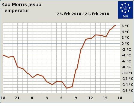
Station is provided by @dmidk at http://www.dmi.dk/groenland/maalinger/vejret-lige-nu/stations/vis/4301 ….
 Edgar McGregor @edgarrmcgregor
 Capital Weather GangVerified account @capitalweather
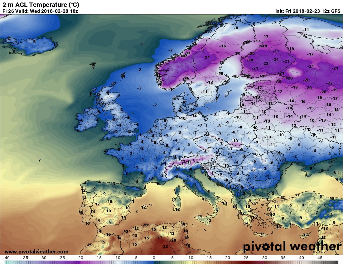
Winter turned upside down! As we watch Arctic temperatures spike to crazy levels, we can follow the southerly winds that are pumping heat into the Arctic. Note: the downside of this circulation is what will bring freezing temps to Europe. pic.twitter.com/7xdgAQASSN
— Randall Gates (@rgatess) February 25, 2018

