I’m going to quote myself from late spring when I attempted to make a summer forecast: “Forecasting for a season is perhaps the most difficult, and as the public knows, most unreliable product put out by any group be it those, for example, from NOAA or people putting together The Old Farmers Almanac. If farmers, power companies, construction companies, those doing a lot of outdoor work, and even health professionals had a good heads up on weather and temperature trends over the course of the next three months literally billions of dollars could be saved, and perhaps some lives as well. Unfortunately, model reliability and long range forecast skill sets are not up to par with public expectations when it comes to seasonal outlooks. Weather forecasts for the next week have gotten remarkably better over the last decade, and there has been improvement in long range outlooks, but current crystal ball methods we have for forecasting seasons leave much to be desired. Knowing the limitations of seasonal forecasting, in this post I will attempt to make a broad forecast for the summer of 2017 in the United States keeping in mind potential dangerous temperature trends due to carbon pollution. By no means am I a skilled seasonal forecaster, but I will give this my best shot knowing that there is a need by the public craving to know what is in store this summer.😊”
All I have to do here is substitute the word fall for summer. My summer forecast wasn’t too shabby predicting the nationally (lower 48) average ranking of temperatures to be well above average but staying out of the top 10:
https://guyonclimate.com/2017/05/24/forecasting-a-hot-summer/
The CONUS, or lower 48 states, saw wild swings in temperature this summer and a ranking of 15th warmest since 1895, out of the top 10 as would be expected as global temperatures ramp up due to carbon pollution. The strength of the Hudson bay low, or upper level vortex, was strong enough and became oriented such that from time to time to cooler than average air masses were ushered into the central U.S.
Here we see state by state rankings for summer 2017:
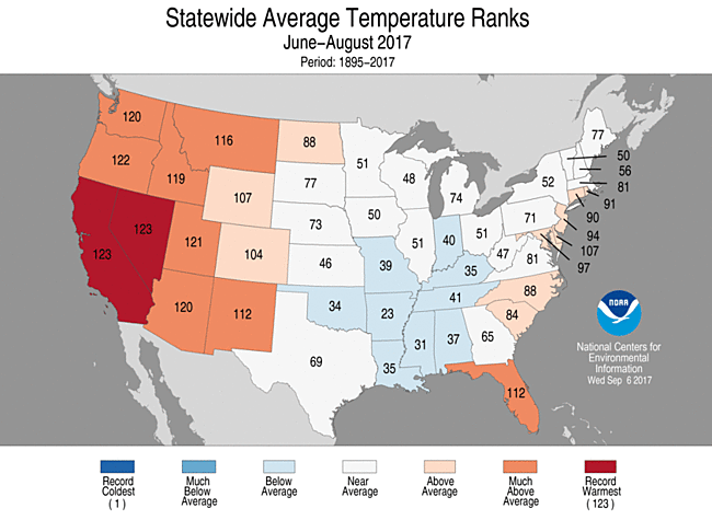
Nevada and California had their hottest summer on record. The cool conditions, which were strongly tied to the strength of the Hudson Bay low, in the south-central states prevented the summer of 2017 from cracking into the top ten rankings. By my count their were seven heat waves or heat episodes from June-August and one notable one in the West in September. The first was in the Northeast in June with one in the Plains and the other five in the West. You can follow the episodes of heat along using my Heat Diary posts.
As far as records go, we didn’t see a dreaded month of a 10 to 1 or more ratio of more daily high maxes than low minimums in the NCEI database, but that “Streak” of consecutive months of DHMX than DLMN continues from November 2014 into September of this year:

The above chart is a huge clue as to what to forecast for in the months ahead for a seasonal forecast.
Question One. Is there any indication of a temporary planetary cool down? Answer: no, so we would expect the trend from the chart to continue.
Question Two. What do sea surface temperature averages look like around North America? Here is the answer:
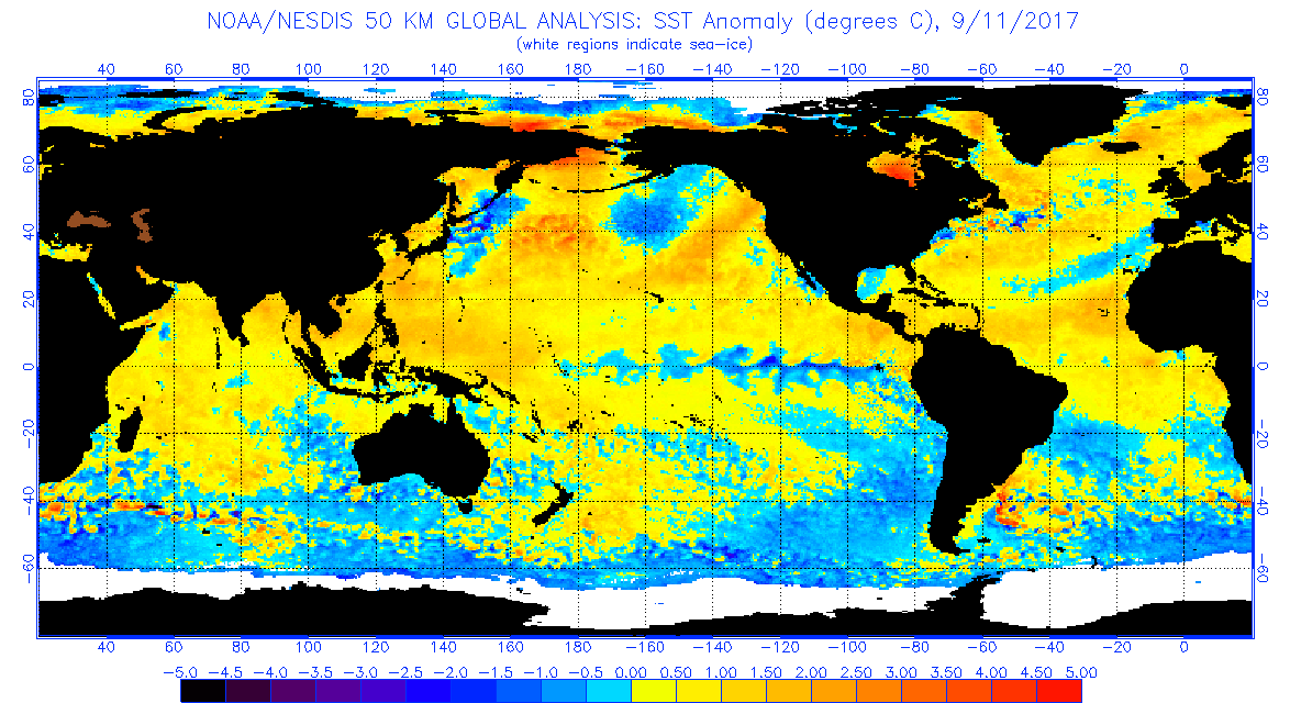
Most of North America is surrounded by above average temperature water including a very warm looking Hudson Bay, which is key to a seasonal forecast. At the start of the summer I saw below average temperatures surrounding North America; thus, I did not think that the summer of 2017 would make the top ten cut:

Well, for once I was correct.☺
Excuses Excuses. I’m a little late with this post due to Irma, so I have a heads up on September averages, which continue to be very toasty in the West due to a historic California heat wave. Sometimes though, for every action in nature there is an equal and opposite reaction to restore equilibrium. Nature may try to do that in the West in about another week, but in turn it could get very toasty in the Midwest and Northeast:

Yes there will be cool snaps from time to time across just about every corner of the CONUS, but will they be cold enough to produce widespread below average temperatures for the fall season? Probably not.
Question Three. Will there be a strong Hudson Bay low or vortex ushering in cold air masses into the U.S. particularly as we go into November? Looking at that European model and noting warm sea surface temperatures in the bay any vortex over or around Hudson Bay will probably be weak and short lived, but with any seasonal forecast there are uncertainties here.
Question Four. Will there be a strong El Nino or La Niña during fall? The answer is neither, except that ENSO in the Pacific region may trend towards that of La Niña as the fall progresses. We can see this for September in that current SST chart:
Note the light blue stripe of blue in the Pacific. A strong El Nino in the absence of a strong Hudson Bay vortex would pump up temperature averages to near record levels as occurred from 2015-2016. I don’t think that ENSO will be much of a factor this fall.
Here is the NOAA prediction for fall 2017:

Right away you’ll notice no blue or below average areas. Given a slight heads up on the synoptic pattern I would expect this chart to verify slightly cooler in the West and warmer in the nation’s mid section. I agree with NOAA not forecasting any blue areas.
Here are NCEI rankings for every season for this decade:

Summer 2017 came in at #109. We are way overdue to see an average or below average season across the U.S. Carbon pollution is definitely making below average seasons more rare. I’m going to guess that the fall 2017 ranking will fall around 115 +or – 5, but my confidence isn’t that high. Given all of the warm factors shown in this post it should be a warm fall for many sections of the country. Let’s see if this forecast will be a bust.😅
You can follow how the fall season is going and pick up $100 to boot by playing my Climate Lottery game here:
https://guyonclimate.com/the-climate-lottery/
Have a great fall!
The Climate Guy