Tuesday September 12th…
Dear diary. Yeah! Our long national nightmare with weather appears to be over since Irma is spinning down, José is forecast to stay away from the U.S., and high heat, smoke, and fires have abated in the West. It will take many months, unfortunately, for residents to recover in Texas and Florida.
I’m ending this post for this year. My next post will be a fall 2017 forecast. Drop me a line for suggestions for improvements for the Summer 2018 Diary.
The Climate Guy
Monday Evening Updates…
Dear diary.
A full 50% of Georgia residents are now without power due to Irma moving north and west from Florida as of this writing. So far I’m not one of them. A couple of people have died around the Atlanta area due to falling trees. The damage would have been worse had winds verified up here like that of Opal from 1998. Instead of gusts to hurricane force top winds in north Georgia were gusting to 50-60 mph.
Despite the verified lower wind speeds currently 1 million are without power in Georgia and 6.5 million across Florida according to @EricHoulthas (7:30 PM EDT) Irma has set the record for power outages set by Sandy in 2012.
For an in depth analysis in why Irma “underperformed” meteorologically see the Jason Samenow Washington Post article: https://www.washingtonpost.com/news/capital-weather-gang/wp/2017/09/11/why-hurricane-irma-wasnt-far-worse-and-how-close-it-came-to-catastrophe/?utm_term=.8e9b5b61d22d
There is some good news on the José front. Here is the official NHC track:
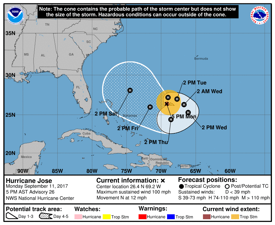
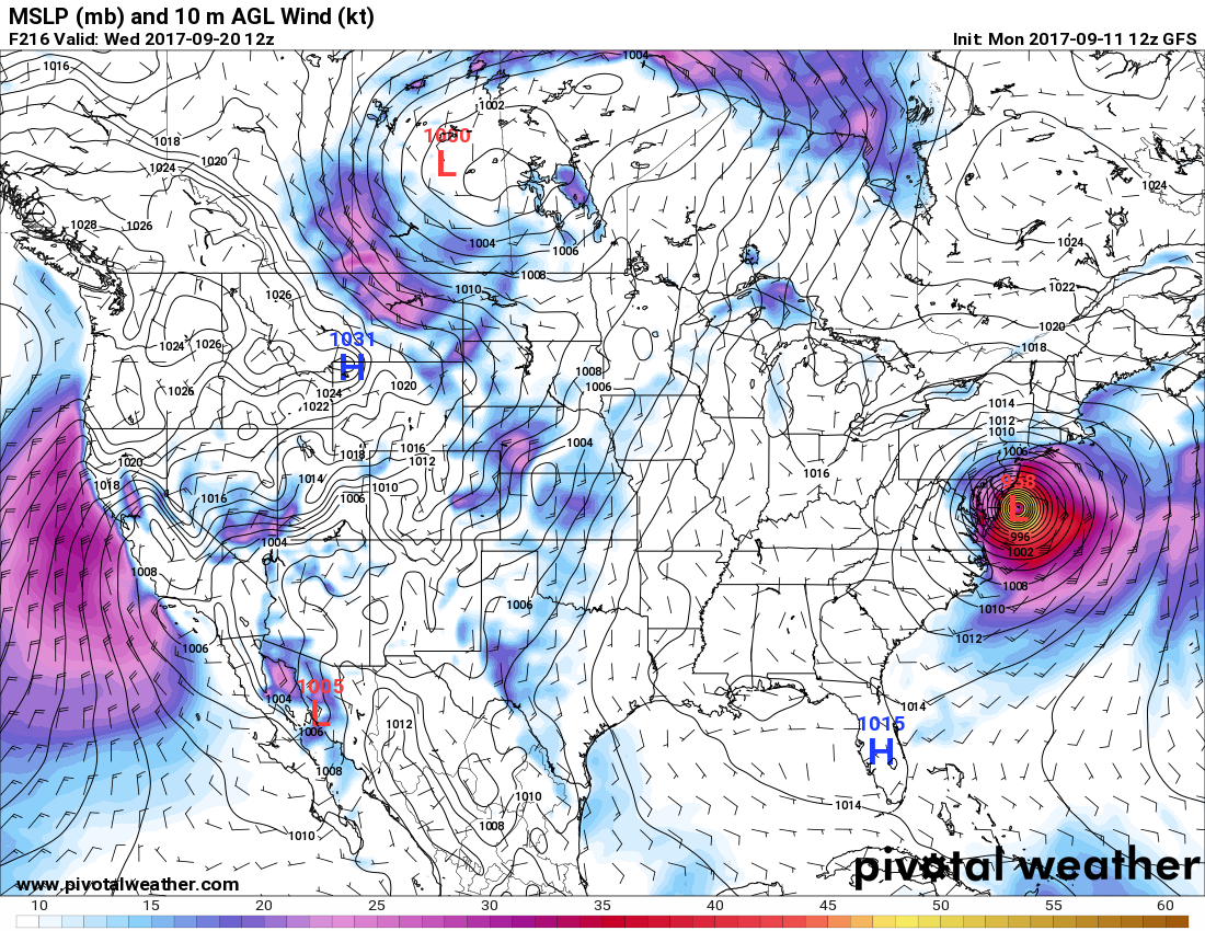
After making a circuitous path José begins to move northwest on Friday and Saturday. Here is as close to the coast as Jose gets according to the operational 18Z MON GFS in 192 hours:

Hopefully José will just be a big, lurking hurricane off the East Coast then get kicked out to sea by a typical early fall front.
I may post more information as it crosses my radar tonight.
The Climate Guy
Monday September 11th…
Dear diary… Unless José is forecast to make landfall or there is another dangerous heat wave it’s time to end the Heat and Flood Diary posts for 2017 after today.
I thank all of the first respondents, weather experts, and officials guiding the public to safety through Irma. Today we’ll look at some storm reports and forecasts in Georgia and Alabama as Irma takes its dying but lashing breaths over those states.
First, as of this writing Irma has been downgraded to a tropical storm with maximum sustained winds of 70 mph in northern Florida. I’ll emphasize that today and tonight most of the ill effects from the system will be in the northeast side of the circulation:

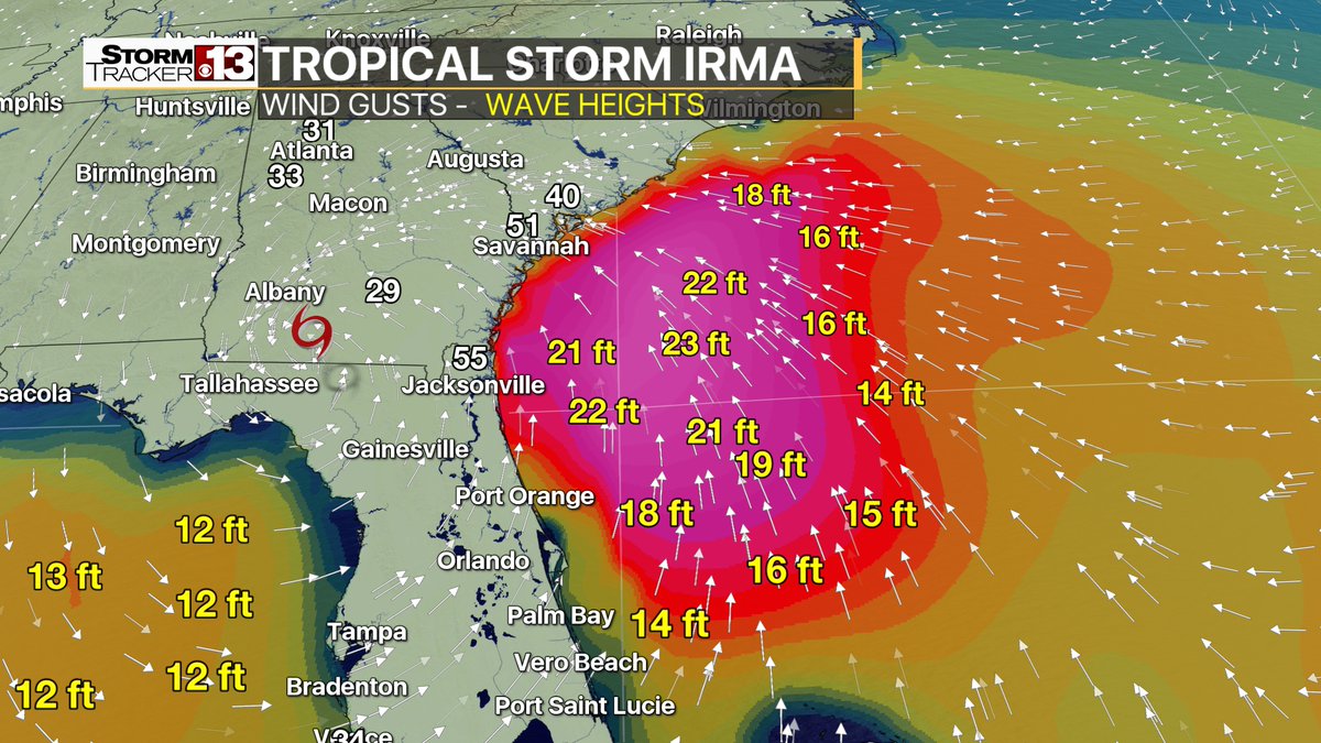
On the east side of Irma storm surge is severely flooding areas from Jacksonville to Charleston. This is a good current graphic (1:00 PM EDT) from Erik Taylor showing surface dynamics creating some high storm surge:
I am constantly reminded of how big Irma actually is.
The worst effects in my neck of the woods in Atlanta will be power outages due to rain in excess of 3-5″ and gusty wind working to damage and down trees in electric lines. There is a slight tornado potential, as well. Irma cut power to millions of people across Florida. It may take weeks to restore power to customers:
http://www.sun-sentinel.com/news/weather/hurricane/fl-bz-fpl-irma-power-outages-20170908-story.html
Since Irma was a degrading storm, even at CAT 4 status at landfall, Florida dodged a big bullet. As bad and broad as Irma’s wind field was, I was not particularly impressed with wind reports except in the Keys and at its second landfall near Naples. Since Irma tracked east of Tampa and weakened that city saw gusts only a little above hurricane force. Most of Irma’s deadly energy was spent in the sparsely populated area of southwest Florida at landfall:
https://www.wunderground.com/cat6/ferocious-irma-pounding-florida-it-could-have-been-worse
Wow though, nearly 6 million Florida residents are without power:

Will Irma be a trillion dollar disaster when all is said and done? I’ll be answering this question in the days and weeks to come.
What about José? Thankfully, the more reliable European model takes the system out to sea, but what worries me is that the GFS consistently brings José up into the Northeast (within my 240 hour rule). Like Sandy this had better not happen:
The good news here is that this morning’s operational GFS is well west of the model ensembles:

Uh-oh. This morning’s European model is trending uncomfortably too the left. Seems like every time I threaten to end this post for the year mother nature intervenes.☹

I’ll be adding to this post today as relevant news crosses my radar.
To see all 2017 Heat Diary entries click:
https://guyonclimate.com/category/heatdiary2017/
The Climate Guy
Sunday September 10th…
Dear diary. My hats off to the European model for both the short range (out to 72 hours) forecast prediction of Irma’s movement and central pressure. Thankfully we never saw a near record low pressure below 920 Mb as the storm passed the central Keys and, thus; Irma only ramped up to a low end CAT 4 (130 mph sustained winds) after weakening near Cuba. From here on out Irma should slowly weaken as it makes landfall near Naples or Fort Myers. Should Irma’s eye wall go slightly west of Tampa there will be a mega disaster due to higher winds and storm surge, which is now only a slight possibility. I’m fed up with the GFS, so my forecasts will mainly be based on European data through about 240 hours out (using my 240+ hour garbage model rule).
This is not to poo poo Irma. It has been a historic, deadly storm and reconstruction costs may top 1 trillion dollars in the U.S. alone. By comparison costs from Harvey may eventually tally around 200 billion.
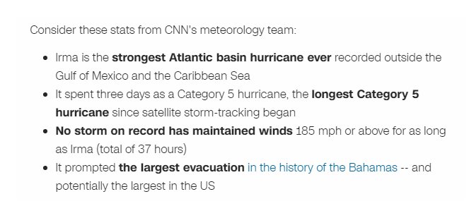
For the first time in U.S. history there have been two CAT 4 hurricanes making landfall in the continental U.S. At the time of this writing (2PM EDT) on social media, for example, I’m seeing warnings like this:

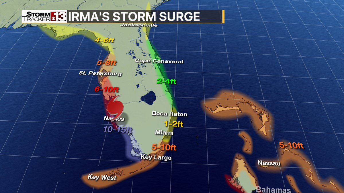
Storm surge of at least 12-15 feet will devastate southwest Florida as has been expected for more than 24 hours:
Here is what Hurricane expert Michael Lowery posted on Twitter:

Here is a crisp graphic of expected storm surge around the Florida peninsula from Eric Taylor:
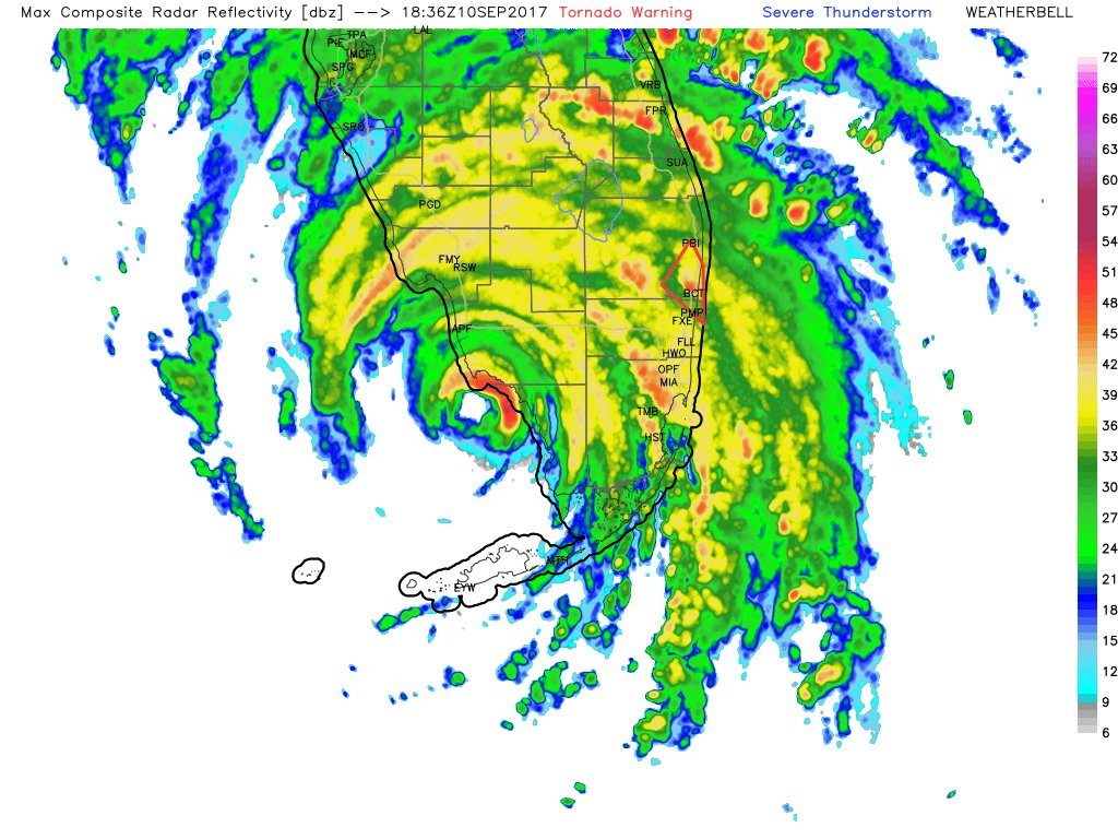
This is a recent WeatherBell radar depiction of Irma making a move on southwest Florida:
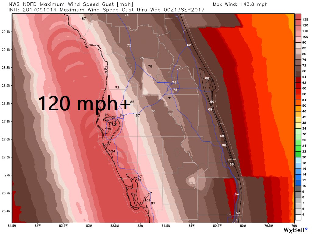
Marco Island had a gust to 130 mph around 3:00 PM EDT.
Naples had a wind gust to 131 mph around 4:20 PM EDT.
If Irma hugs the west coast of Florida winds will be very intense and devastating (WeatherBell Image from Ryan Maue):
Monday into Monday night Irma will be coming up into my neck of the woods, Atlanta. The pressure gradient between Irma and high pressure over the Northeast will produce “wedge-like” effects in Georgia. Winds in Atlanta could be gusting to near hurricane force Monday evening.

This blog will be very fluid tonight as new information comes across my radar.
The Climate Guy