Friday June 11th…
Dear diary. Today should be the last day of heat wave #5. Yeah! Smoke has plagued the Pacific Northwest in association with the heat wave this entire month. Here is a recent satellite image from NWS Boise:

Many stations are reporting unhealthy air. Southwest flow tomorrow should remove much of this smoke.
It’s been quite the heat wave. For example, according to NWS Seattle during the first ten days of August the average max at Seattle was 88.1F, which was the warmest first ten days of August at Seattle in 120 years of record keeping.
This chart from MDA Weather Services depicts the temperature pattern we have seen for the first ten days of August:

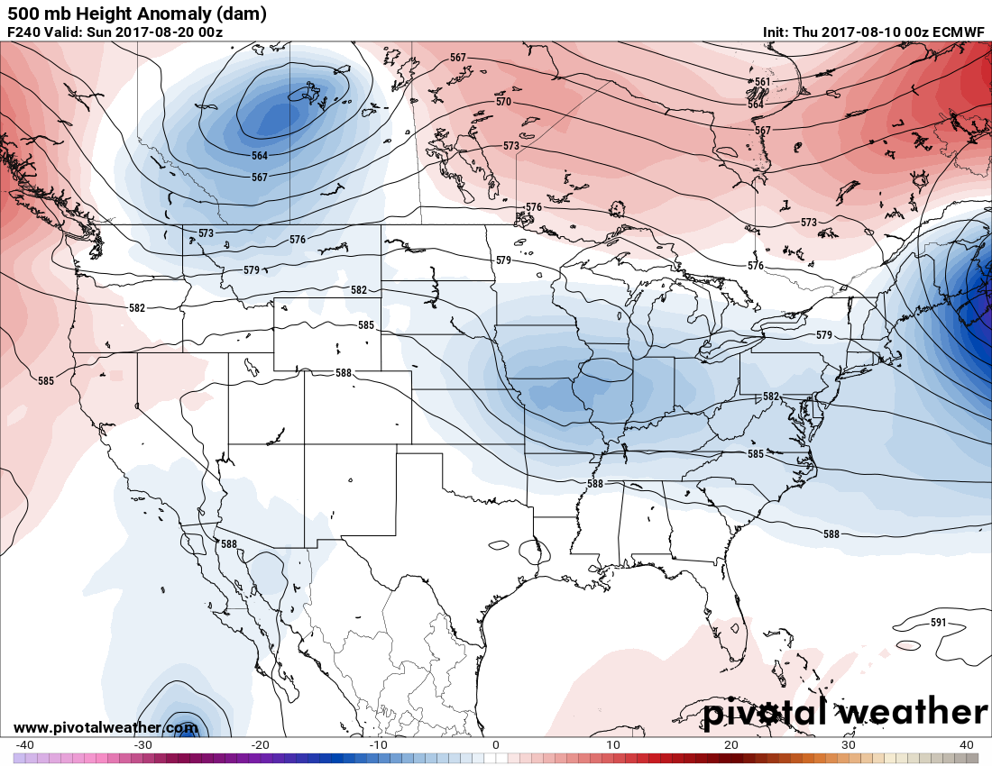
My meteorological tea leaves are suggesting that the West will catch a break from the heat while the South warms up during the second ten days of August. Both the operational European and American (GFS) models are coming into closer agreement. Here is what we see by the 18th:

Notice that at 500 Mb we have a near zonal, or meteorologically a west to east flow with minor perturbations. The 588 decameter line bisects or cuts the nation in half. Any dangerous heat should be south of the 588 line using one of my rules of thumb. The forecast heights across the U.S. are quite average for mid-August, however.
Tomorrow Seattle should fail to make 80F. A cooling trend will commence in the West while indeed, the South gets a little warmer. The U.S. should be devoid of any heat waves:

The national maximum temperature chart for Friday was not available this evening.☹
The Climate Guy
Thursday June 10th…
Dear diary. Today we will look at model data to see if there is any possibility of another heat wave in a portion of the U.S. before the summer ends. Over the last few days I have delved into why the current weather pattern influenced by a fairly strong Hudson Bay vortex has put a big kibosh on heat across the area east of the Rockies. Will there be a pattern change before the sun angle gets low enough going into September that we really can declare that “summer is over?”
My first rule is never to look at models past 240 hours, which are mostly garbage. The most reliable model is the European, which definitely does not forecast a hot weather pattern at 240 hours out. (note a lot of blue color inside if the U.S. border):
On the other hand at 240 hours out the GFS shows a big pattern change:

Notice that the Hudson Bay low with its associated cold anomaly has disappeared and has been replaced by a warm anomaly (in orange). A blue area of below average 500 Mb heights has made an appearance over Alaska and western Canada. Both factors in my experience usually lead to warmer conditions east of the Rockies. Just how warm after August 15th remains to be seen.
In the meantime our 5th heat wave of the season will be ending shortly in the Pacific Northwest. Here are tomorrows model forecast maxes:

A weak system will be just strong enough to bring onshore flow to coastal areas of Washington and Oregon to reduce heat at Seattle and Portland. Also, smoke should start to clear away from the area once this trough moves onshore and shifts winds toward the southwest by Saturday.
Here are today’s maxes:

Our “mild” pattern continued across the U.S. There were a few hot spots in the West, Texas and the South. Dallas managed to make 100F.
To see all 2017 Heat Diary entries click:
https://guyonclimate.com/category/heatdiary2017/
The Climate Guy