Monday July 31st…
Dear diary. July has been a notably torrid month in two large American cities. Both Miami and Salt Lake City have had their hottest month in their history. Most of the record highs in July were set during the third major heat wave of the season during the first week of the month in the West. Though dangerously hot, a fourth heat wave during the third week of July across the Plains and South did not set that many records. A fifth heat wave set for early August in west coastal states should set many records. Summer 2017 will go down in history as the summer of record heat and fires in the West.
As noted by Bob Henson writing for Category 6 the next heat wave to affect the United States will be prolonged and blisteringly hot:
Quoting some forecast stats from Bob’s post:
“Some all-time record highs could be in jeopardy across the Pacific Northwest, especially in the valleys just inland from the coastal mountain ranges. Here are some of the most vulnerable all-time records, together with WU forecasts issued on Sunday night”:
Olympia, WA
All-time high: 104°F, most recently on July 29, 2009 (records begin in 1948)
Forecast high for Thursday: 106°F
Portland, OR
All-time high: 107°F, most recently on August 10, 1981 (records begin in 1940)
Forecast high for Thursday: 107°F
Eugene, OR
All-time high: 109°F on August 9, 1981 (records begin in 1912)
Forecast high for Wednesday: 110°F
Medford, OR
All-time high: 115°F on July 20, 1946 (records begin in 1911)
Forecast high for Wednesday: 114°F
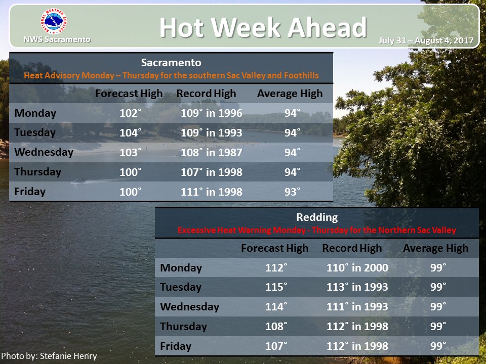
Redding, CA
All-time high: 118°F on July 20, 1988 (records begin in 1983)
Forecast high for Wednesday: 115°F
Here are some of the latest sweltering forecasts from northern and central California:
I would not be surprised if more dry weather fires broke out in the Pacific Northwest or California from this latest heat episode. At least heat wave number five will be waning by this coming weekend. The Weather Service is definitely concerned about this weather pattern, and so should all residents of the West:

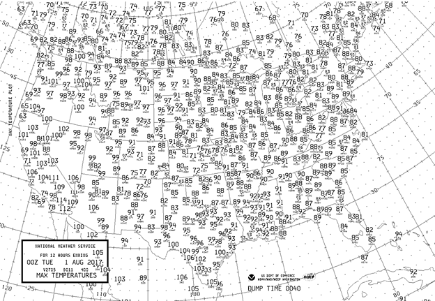
Here are the model forecast highs for the first day of August:
Near record heat will be building in California and Oregon. No noteworthy heat will be occurring east of the Rockies.
We can rack up one more record high in California for July 2017 (graphic from @AnthonyNBCLA):

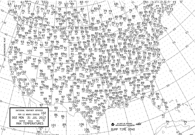
Here were the maxes for the last day of July:
Heat was building northward into Washington and Oregon. Due to Tropical Storm Emily Miami stayed below 90F. Overall, temps weren’t too unbearable for the last day of July 2017.
The Climate Guy
Sunday Evening Updates…
Dear diary… The NCEI record site has updated, and very few records (either cold or hot) were recorded across the U.S. from 7/13 to 7/27. It’s now certain, though, that July 2017 will be the 32nd consecutive month of more daily high records than daily lows in the United States:

Here are Sunday’s maxes:
When climate reports are written about July 2017, another very hot state, besides California, will be Montana where several stations got above the century mark today. Western Washington and western Oregon will be much hotter tomorrow.
The Climate Guy
Sunday July 30th…
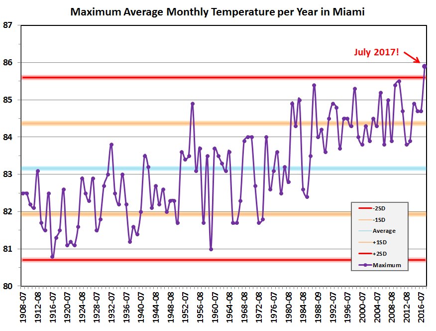
Dear diary. Looking at model ensemble guidance the first week of August will be one of extremes with record heat along the West Coast, and perhaps record cool conditions in the Midwest. Before we leave July, which won’t be regarded as a particularly hot month, average wise, across the U.S., one stat is an eye opener. Miami FL will have its warmest July and month by a considerable margin (chart from Brian McNoldy):
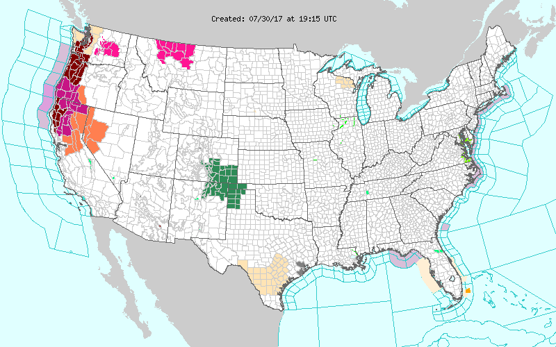
Heat advisories have been posted for heat wave #5 across the West:
Tomorrow heat will once again be building in the West while most of the rest of the country will have pleasant temperatures:
I’ll be adding to this post as pertinent information comes to my attention.
The Climate Guy
Saturday Evening Updates…
Dear diary. This morning my post was all about the coming cool weather in the East. Shame! Shame on me…I neglected to write about the coming heat in the West. Before we get to that… and also my bad…I should have “unofficially” extended heat wave #4 a couple more days for the southern heat. Ryan Maue pointed out that some record heat occurred south of our heat relieving front in South Texas and Florida (noted by the circled numbers):

And now to heat wave #5. Yep, the coming weather pattern will be hot and prolonged enough from California into the Pacific Northwest for me to arbitrarily declare a heat wave. Since my report this morning heat watches have been expanded into western Washington and Oregon. Montana should also stay hot:

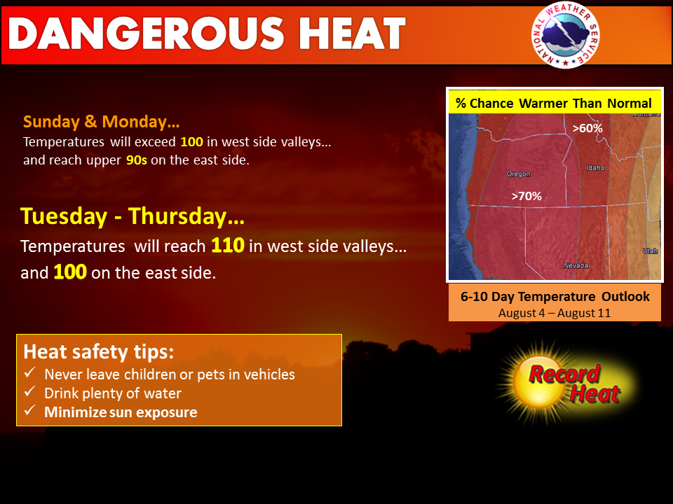
This is the forecast from the NWS out of Portland OR:
This fifth heat wave, although starting first, will coincide with our big cool shot moving into the Midwest. In the world of weather sometimes for every action (heat wave) there is an equal and opposite reaction (cold wave) except when carbon pollution increases imbalances in the environment. It will be interesting to see how many records, both cold and hot are set in the first couple of weeks of August.
So what will our western heat dome look like near its zenith? Here is the GFS from today valid Thursday afternoon:
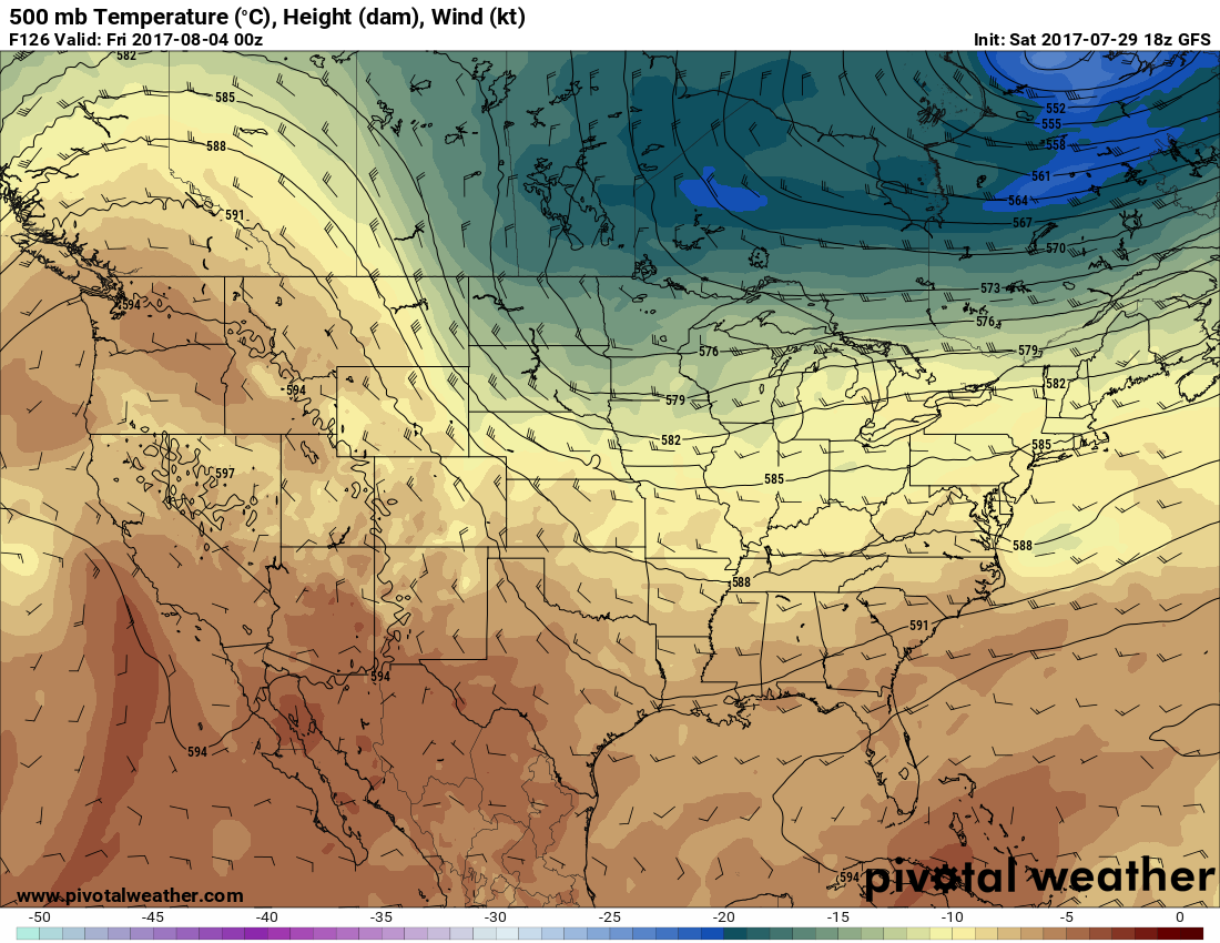
Note the 594 decameter height line getting up to Seattle while our Midwestern system is starting to dig south towards Minnesota.
Alex Lamers noted this statement from the Weather Prediction Center earlier today:
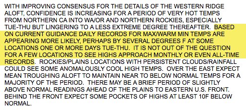
Interesting times are ahead, indeed.
Here are Saturday’s maxes:
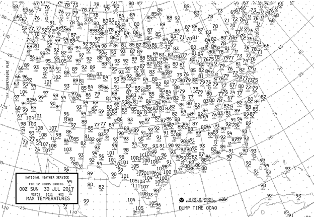
Indeed it was hot enough, perhaps, to produce several record highs in south-central Texas. Pleasant conditions occurred in western Washington and Oregon where it will be getting much warmer the next several days.
The Climate Guy
Saturday July 29th…
Dear diary. We are now closing out the month of July. So what will be in store, temperature wise, in early August? To all of my climate friends… surprise!…a decent cool snap. Yes, I promised on June 1st when starting the Heat Diary that I would also point out weather patterns that might lead to record cool conditions during this summer.
All summer long the Upper Midwest and New England have been the nation’s cool spots. Yet another system has rolled through this area into the Northeast this weekend dragging a cold front in its wake that has put a big kibosh to most dangerous heat east of the Rockies. In a few days a system will strengthen in the Great Lakes that will make the current system that is bringing a chilly rain to the Northeast pale in comparison. Let’s see why.
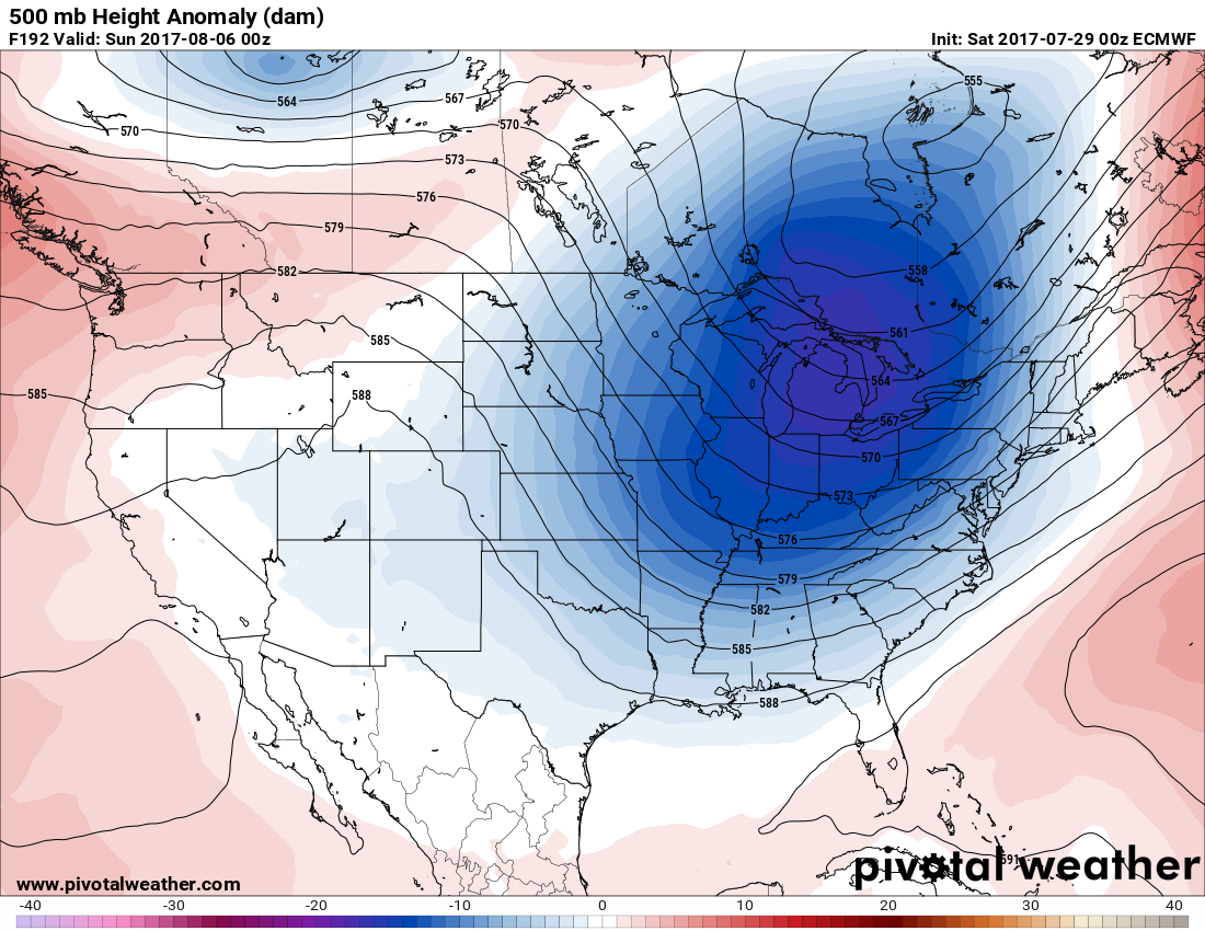
The more reliable European model first keyed in on this strong, cool system yesterday continuing what I will term the “cold phase” jet stream pattern over the eastern U.S. How does this cold phase pattern develop? The first signs I look for come from those Penn State ensembles. When I see a warm ridge nosing northward into western Canada and a positive, warm anomaly develop over Greenland (in orange) the polar jet gets pinched off around Hudson Bay and begins to dive southward into the U.S. A positive anomaly over or near Greenland is termed the negative phase of the North Atlantic Oscillation. During the winter a positive NAO usually spells bitter, cold weather for the eastern U.S. During the summer a positive NAO usually gives the East a break from heat.
Here is the described forecast pattern that caught my eye today:
At 192 hours out a cold anomaly develops across the Great Lakes:
Here is the operational European model forecasting a very substantial cold anomaly over the East. I typically see such a 500 Mb pattern in late September or even in October, not in early August:
I’m certain that such a cool or cold pattern will produce some record lows in many locations east of the Rockies. I’ll definitely report on exact numbers in time. Don’t forget that the latest climate models do forecast cold enough weather in the year 2100 to see about a 15-1 ratio of daily record highs to lows in the U.S. The “cold phase” of the jet will be how record lows will continue to be set as we move forward through the 21st century. Gradually, as has been the case since about 1980 due to carbon pollution, the cold phase pattern has become less potent and more rare.
Tomorrow cooler air will be seeping into Texas where triple digit heat has recently been occurring. California will become the nation’s lone hot state where heat will be increasing, particularly in northern California where heat watches have been posted. Most of the CONUS should see pleasant temperatures for late July:
I’ll be adding to this post with updates later today.
To see all 2017 Heat Diary entries click:
https://guyonclimate.com/category/heatdiary2017/
The Climate Guy