Saturday Evening Updates…
Torrid conditions continue across much of the Plains, Mississippi Valley and South due to the combination of high dew points above 70 and high temps above 90F, so for this evening I’ll present a couple of areas that local news organizations have highlighted for high heat indices:
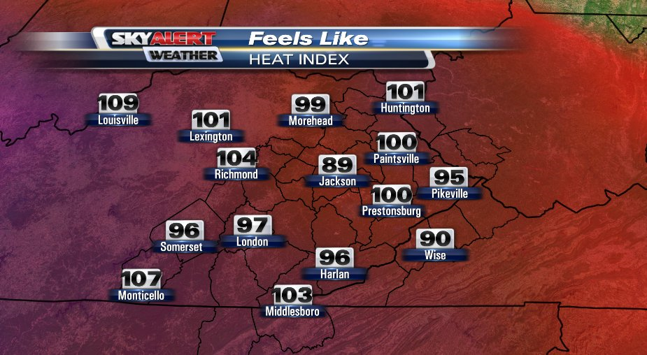
The first is from Arden Gregory out of central Kentucky:
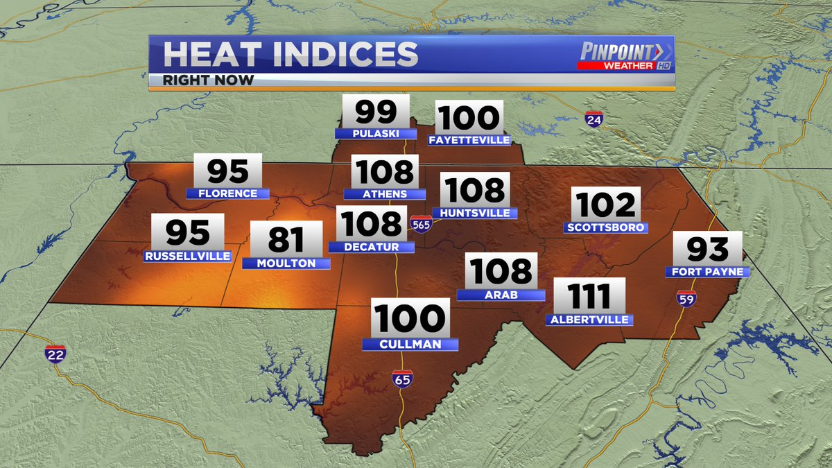
The second is from Austin Winfield out of northern Alabama:
Dangerous values well above 95 have been quite common across NWS advisory areas. As they say in the South, it’s not the heat that will get you, it’s the humidity.
Just for fun and giggles please use this NWS handy on-line calculator to calculate the heat index for your location:
http://www.weather.gov/epz/wxcalc_heatindex
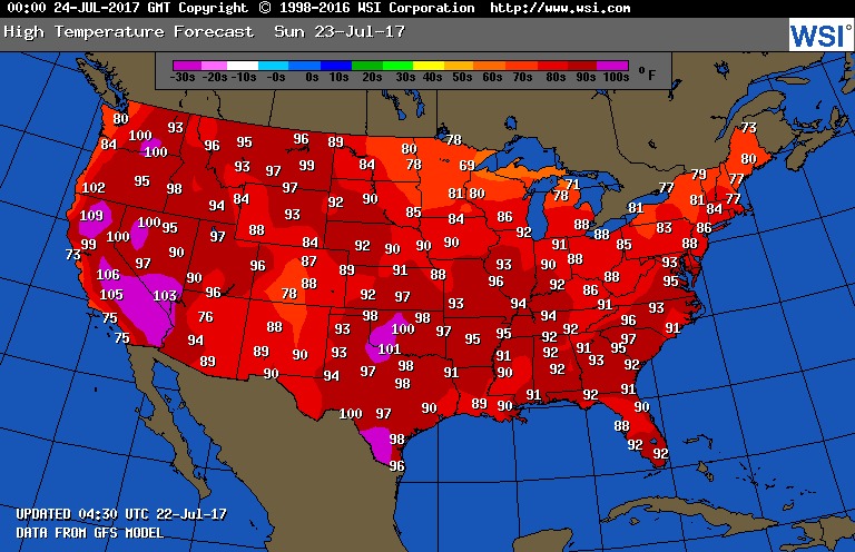
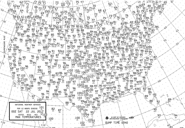
Here are today’s maxes:

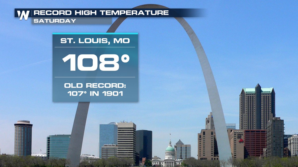
Raleigh NC got over 100F for the first time this summer. What stands out like a sore thumb is the record high of 108F at St. Louis, which was about 8 degrees higher than surrounding stations. The temp may have gotten that high due to a combo of the urban heat island effect and station placement, nevertheless another record gets chalked up:
The central and southern Plains continued to swelter with most locations exceeding the century mark.
The Climate Guy
Saturday July 22nd…
Dear diary. It appears that our fourth heat wave of the season is diminishing, but will be stubborn to leave before the end of July. In fact, the thing might be with us going into August. I will arbitrarily declare its demise when the time comes. At least heat advisories have come down for the Northeast today. On the other hand, more advisories have gone up in the Southeast than what we saw on Friday:

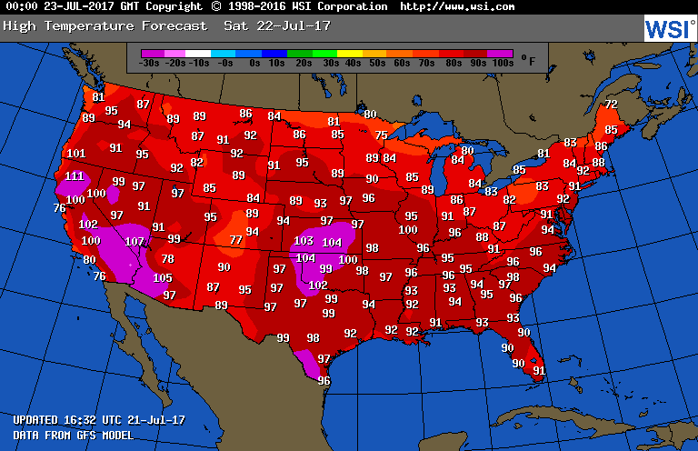
Tomorrow there should be a further slight reduction in the heat most places. By the way, European model temperature forecasts are better than those from the GFS, so please drop me a note where I can find national maps of those plots if they exist. For now, we’ll just muddle along with these:
It would appear that at least a low grade heat wave will persist from the Southwest into the central and southern Plains next week. I’ll keep all informed on the latest model guidance, of course.
Bob Henson on his Weather Underground, Category 6 blog has an excellent summary of the latest U.S. heat wave and writes about the latest heat wave in China here:
https://www.wunderground.com/cat6/heat-sweat-and-ozone-plague-us-all-time-high-shanghai
I’ll be updating this post with any pertinent news later today.
The Climate Guy
Friday Evening Updates…
Dear diary. My neck of the woods, Atlanta, had its hottest max so far this season today reaching 94F. Yes, some places, despite carbon pollution steadily increasing global temperature averages, can still have relatively mild summers, and it appears to be Atlanta’s turn. Personally I’m pleased that it has not been as torrid here as last year. There is no drought in north Georgia, which has led to an abundance of green flora, which has helped to temper maxes.
Now I’m going to get on my soap box. Just to get this off my chest, I saw a CSX train that had at least fifty coal cars moving south yesterday when I was on the way to the Cobb County Aquatic Center for exercise. I have never seen this many coal cars on one train on this track since I have been living at my current address since 2001. For the first time I saw a locomotive that was hauling nothing but coal. I wondered why on Earth is this much coal being shipped toward Atlanta? Those who want a green, vibrant Earth are up against a big headwind resistant to change, and this to me was more proof. Common people just shrug off such coal deliveries, especially during a time of relatively “normal” weather.
When a place has a mild summer, even in this day and age, people living there tend to doubt dire predictions from outlets like Climate Central. I have noted on Twitter people scoffing at these forecasts:
http://www.climatecentral.org/news/summer-temperatures-co2-emissions-1001-cities-16583
There are even people who are falsely debunking what Climate Central, and governmental climatology offices put out on sites like https://realclimatescience.com/
Don’t believe anyone except those from NASA, NOAA or those with climatology degrees who more than likely have published peer reviewed papers.
O.K. I’m off that soap box. It’s time to present today’s maxes:
Wow it was hot in the Plains! There had to be a few records somewhere in that large mass of 100’s. St. Louis stands out at 104F. Heat Index values were well above 110F from Iowa south to Arkansas. Again, the GFS yesterday was too cool in the Plains. Yep, this is a heat wave.
On the bright side maxes were a degree or two cooler in the Megalopolis area from yesterday, and will continue to cool this weekend.
The Climate Guy
Friday July 21st…
Dear diary. My designated 4th heat wave of the season should be at its peak today. Heat advisories and warnings have steadily been taking up more real estate across the country with each passing day this week. This is what we currently see:

By know means will the current heat wave be ending, though. In fact the thing may wane early next week only to stick around and make a comeback later next week, particularly in the central and southern Plains, and Mississippi Valley. Tomorrow’s highs should be just a degree or two cooler at most locations than today, but dangerous heat will be persisting in the Northeast, Southeast, Plains, and Midwest:
So, why will this heat wave not be ending early next week? In my last couple of posts I indicated that the heat dome will be persisting over the nation’s mid-section. The good news is that a big chunk of the dome will be sliced away from a cold system (or front) moving through the Great Lakes and Northeast south around a typical Hudson Bay low. All summer long there has been a battle going on between the cool regime in association with the Hudson Bay low and the western heat dome, which from time to time has extended well east of the Rockies. What will be left of the heat dome next week should be centered over or near Oklahoma:

Actually, this is a fairly typical looking 500 Mb chart for late July. Notice, though, that the 588 decameter line covers more than half the country. That much of a heat dome will translate to persistent, dangerous heat at the surface:
I would anticipate that the above GFS values will be a little higher in the Plains and lower in the Southeast as has been the case the last couple of weeks. The Great Lakes and New England will have very pleasant temperatures.
The West continues to suffer from heat wave related large fires. Bob Henson of Weather Underground has written an excellent post on the Detwiler fire and other current conflagrations:
https://www.wunderground.com/cat6/states-emergency-california-british-columbia-raging-wildfires
Of course, global warming is playing a big role exacerbating the western wildfire situation as reported by Climate Central:
http://www.climatecentral.org/news/report-the-age-of-western-wildfires-14873
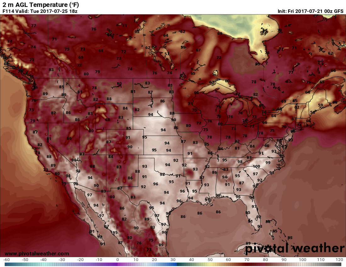
Yeah! We now have a better tool to forecast heat. The GFS was updated recently and now has much better modeled urban heat islands. Here is an example from Ryan Maue:
Touching on world news today, Shanghai, China, the planet’s most populous city, just set an all-time max of 106F. Incidentally 106F is the all-time max for my hometown, Atlanta GA set in July 2012. I know how you feel Shanghai!
I’ll be adding to this post with updates later today.
To see all 2017 Heat Diary entries click:
https://guyonclimate.com/category/heatdiary2017/
The Climate Guy