Wednesday June 14th… Dear diary. As surmised yesterday our emphasis on extreme heat will turn to the Southwest where excessive heat watches and warnings have already been posted. You can look at my heat diary for prior days in June here:
https://guyonclimate.com/2017/06/07/summer-2017-heat-diary-log-two-june-7-14/
As I will continue to emphasize, the first clue to look at for extreme temperatures is half way up the atmosphere on 500 Mb anomaly charts. It would appear that a southwestern ridge is currently building and will start producing near record heat this weekend:
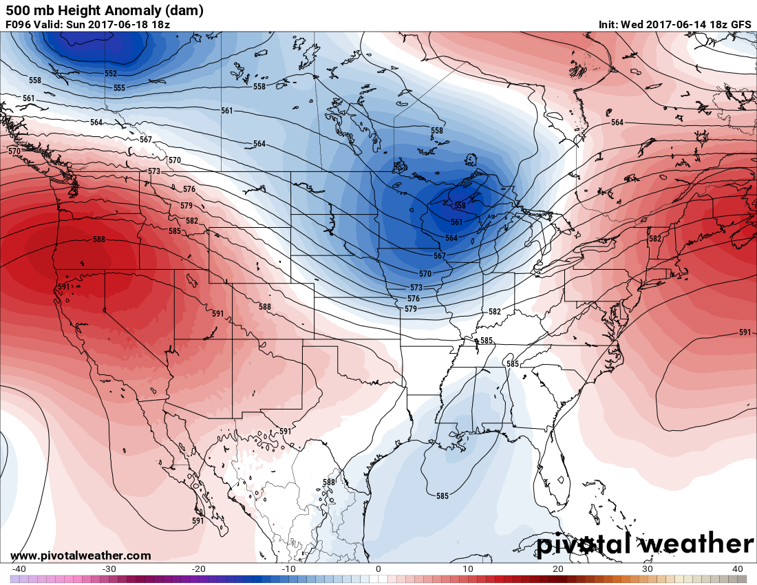
The darkest reds are in Oregon, so I suspect that near record heat will be building northward through that state by Sunday.
Indeed, model surface temperature guidance forecast maxes near 120 in Phoenix early next week, which even by their standards would be blisteringly hot. If it gets near 120 at Phoenix there is a chance that it might get near 130 in Death Valley, which would be close to an all-time record maximum temperature for the planet:
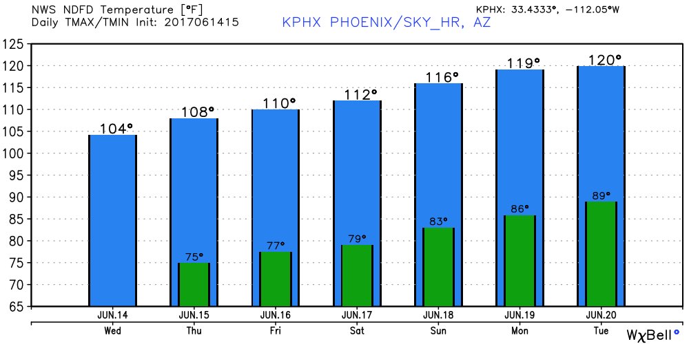
(Image from Ryan Maue and @NWSPhoenix)
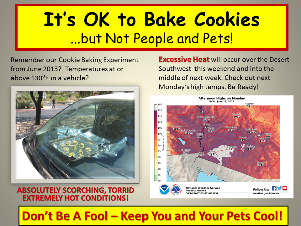
The Phoenix NWS office has displayed some tips for the coming heat wave:
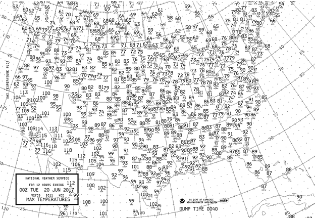
What about tomorrow? The GFS predicts the following:
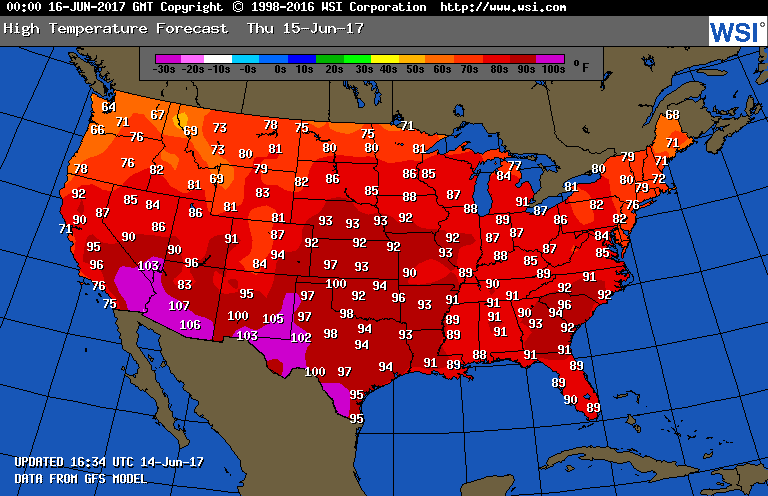
Temperatures will be a few degrees above average just about everywhere across the U.S., but there should only be a few record maxes from New Mexico into West Texas.
It certainly appears that June 2017 will be the 31st consecutive month of more daily record highs than lows in the NCEI database looking at model ensembles going through the month’s end. I’ll report on any record heat or cool conditions on this post as we roll along to the first official day of summer on June 20th.
The Climate Guy
________________________________________________
Friday June 16th… Dear diary. Extraordinarily high heat will begin in the Southwest today and last through next week. Heat advisories and warnings are up for much of California and Arizona. Near record heat will be a problem in portions of New Mexico and Texas, as well, today. Advisories are up for today south of Kansas City and around Dallas due to high heat index values, although the heat there will not be record breaking:
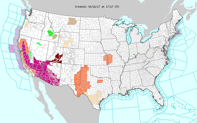 (Please see this NOAA site for details: http://www.weather.gov/)
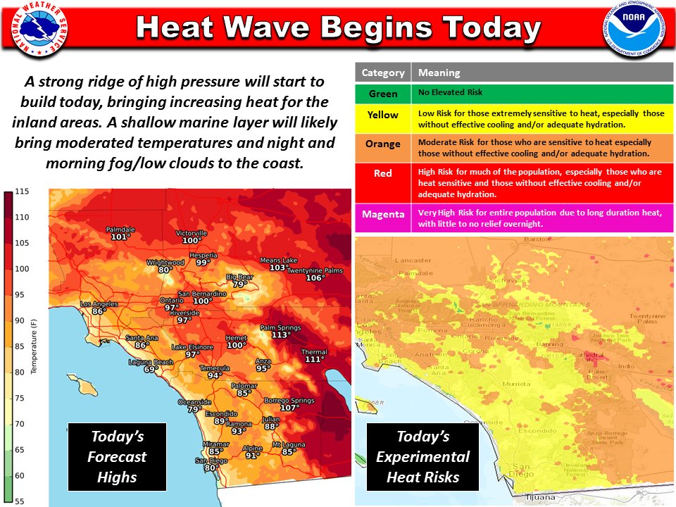
Southern California, particularly in the desert, is starting to bake today. The following graphic from NWS San Diego paints the story well:
Here are the forecast maxes across the nation for today. Maxes above 100 coincide with the advisories:

What does the upper level pattern look like over the Southwest by Tuesday of next week when the heat wave may be at its zenith? This 500 Mb chart from Pivotal Weather shows the well forecast building ridge:
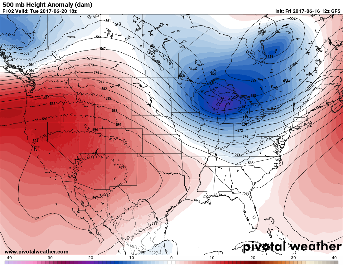
It looks like there will be a near 599 decameter ridge centered right over Arizona… about as high as I have ever seen in my 30+ year career as a meteorologist. That forecast of near 120F at Phoenix for Tuesday is still holding. The following graphic from WxBell and Ryan Maue indicates that the heat will be dangerous even by Arizona standards:
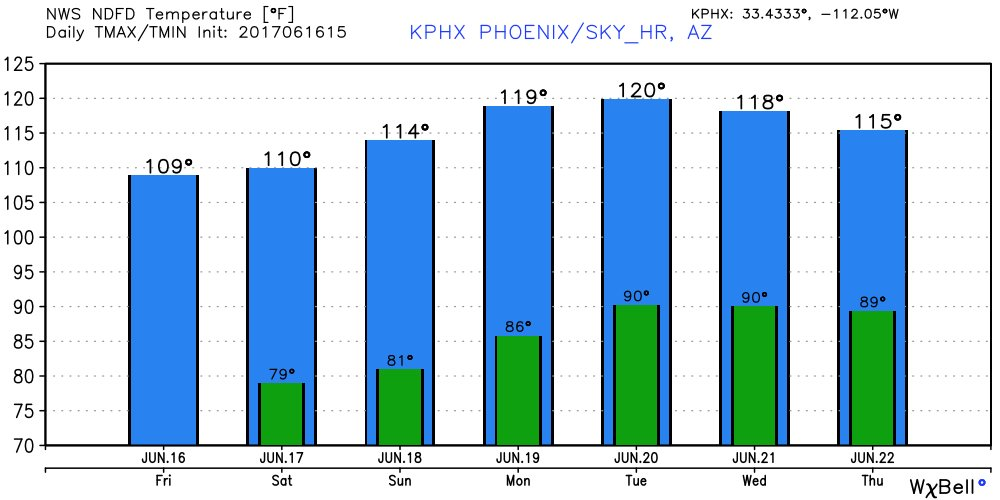
The last time Phoenix was 120F+ was on July 28, 1995. The following graphic shows how rare getting above 120F at Phoenix is:
No doubt many records will be set in the Southwest from this synoptic pattern that I would argue is only made worse by greenhouse gas pollution. Here is one other tidbit. All calendar months during this decade have had more daily record highs than lows. I have noticed that the disparity between DRH and DRL is greatest during June, which I think is just a random quirk. Drop me a line if you can explain the reasons for the disparity:
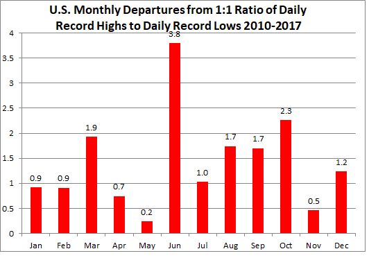
I have no doubt that the building heatwave this month will just lengthen the bar for June in the chart.
Local governments are preparing for the ravages of heat waves due to climate change. New York City just had a heat wave in which LaGuardia Airport got up to 101F. I saw this report today from New York City:
Quoting from the report:
“Climate change is a dagger aimed at the heart of our city, and extreme heat is the edge of the knife,” said Mayor Bill de Blasio. “This is a question of equity; hotter summers, exacerbated by climate change, are a threat that falls disproportionately on communities of color and the elderly. We are answering that question with programs designed to protect the health of New Yorkers, expand our city’s tree canopy, promote community cohesion, and more.”
“Every year, hot summers cause dehydration, heat exhaustion, and heat-stroke – all outcomes that disproportionately impact older adults and vulnerable populations. Extreme heat kills more New Yorkers than any other extreme weather event, and leads to an average of 450 heat-related emergency department visits, 150 hospital admissions, 13 heat-stroke deaths, as well as 115 deaths from natural causes exacerbated by extreme heat.”
So what is the “Record Genome Score” after last weeks heat wave in the Northeast and cold system or shot in the West? I’ve updated these numbers for 2017 through 6/14:
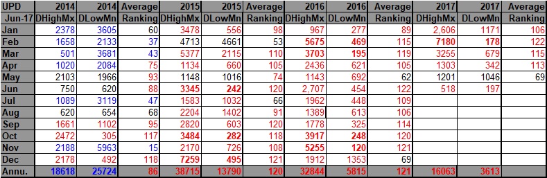
As per usual with global warming, there were far more record daily highs (512) than lows (197) in association with the extreme synoptic pattern, despite that snow in the Sierra.
Dear diary. That’s it for today. I’ll add to you as more reports on the coming heat wave get in the news.
The Climate Guy
________________________________________________
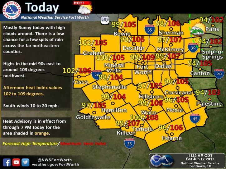
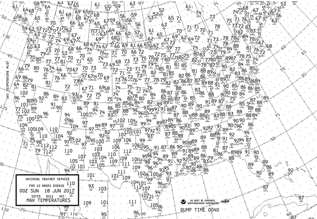
Saturday June 17th…Dear diary. The western heat wave has commenced, but it is also getting brutally hot in the Plains. This NWS chart depicts yesterday’s national maxes for Friday:
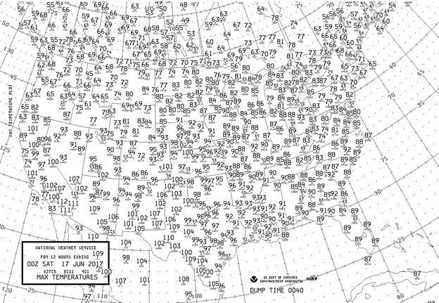
It got up to 109F at Phoenix, but considering how hot the forecast is over the next week, it was a cool day.😉 Highs above 100F were experienced from west and south Texas northward into the western High Plains.
Dangerous heat considering the heat index is occurring through portions of the central and southern Plains today. Note all of the NWS advisories:

Note the maxes and heat index values forecast for this afternoon from the Dallas NWS office:
Record heat is forecast today for Roswell NM, Lubbock TX, and Midland TX :
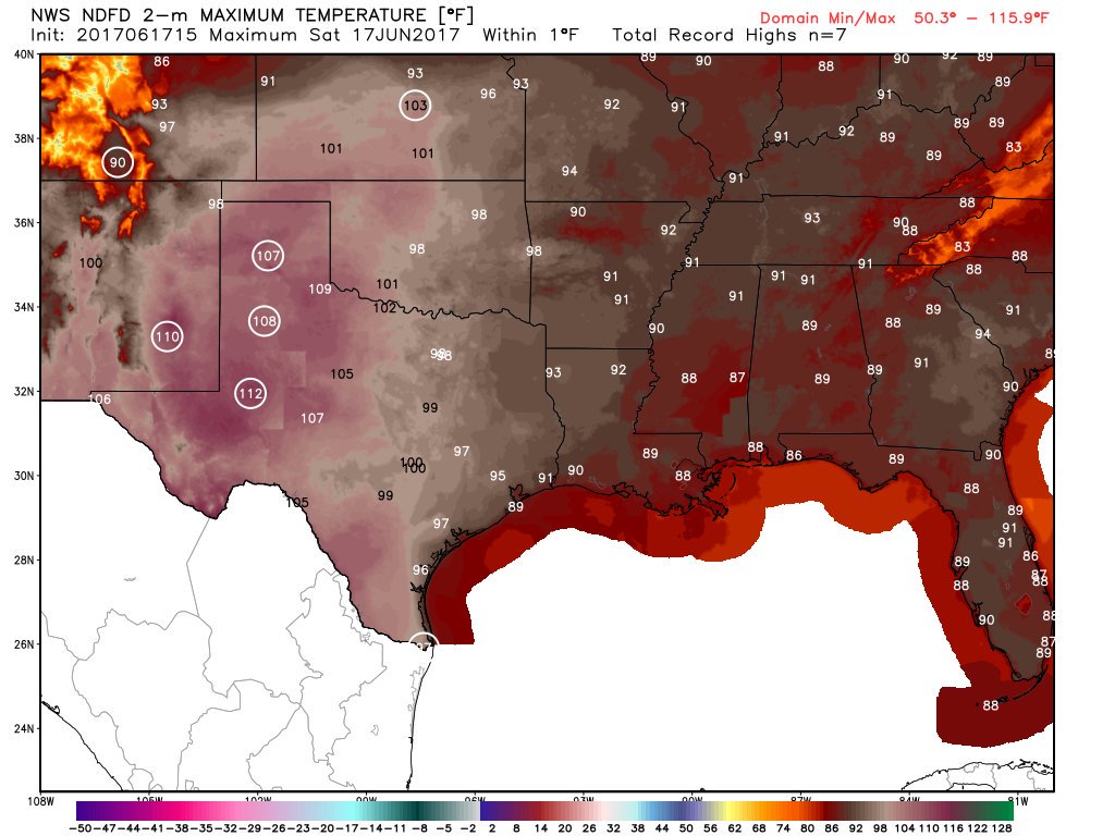
Here are the national highs forecast by the GFS from Intellicast and WSI:
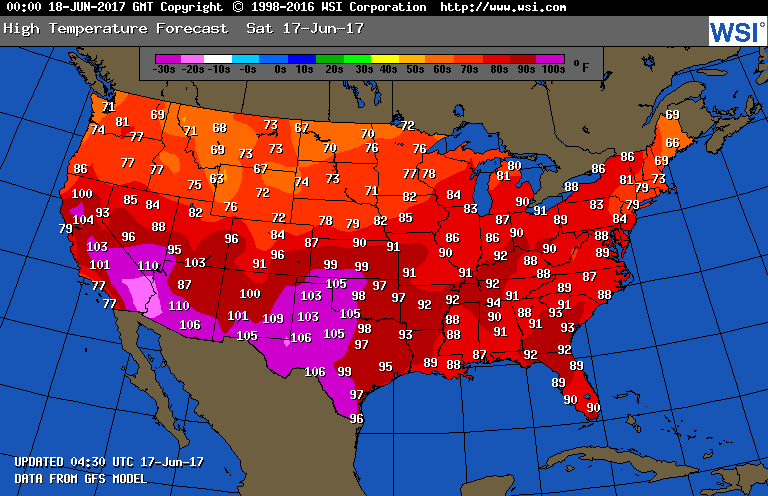
The nation, overall, should have a pleasant Saturday except in the warned areas for heat. I would expect some records to fall in the western High Plains, but southwestern records should hold.
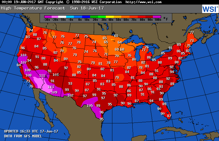
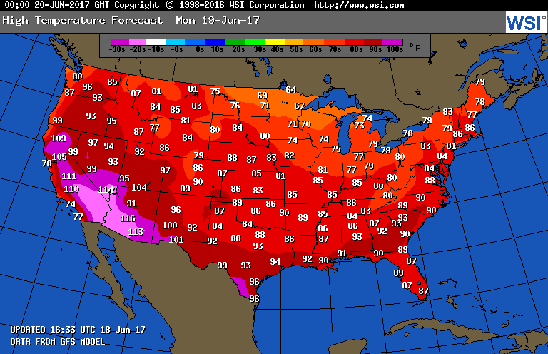
What about Sunday? This WSI chart paints an even warmer picture for the Southwest, but the western High Plains should get a break from the heat:
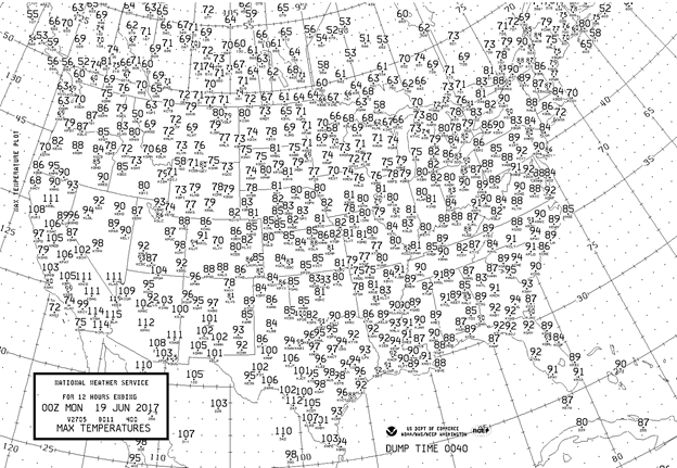
An update: Lubbock TX got up to 112F at 3:57 PM CDT. According to Bob Henson (@bhenson) this is the first time it has gotten above 110F at Lubbock before the summer solstice in 105 years. The following NWS chart shows today’s maxes for the major reporting stations across the country:
Notice that it got to 110F at both Vegas and Phoenix. It will be a lot hotter across the Southwest the next few days.
________________________________________________
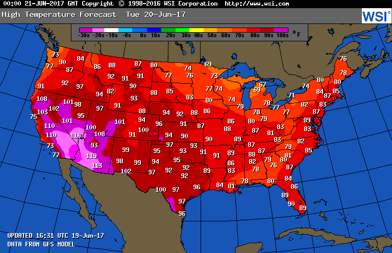
Sunday June 18th… Dear diary. High heat will be confined to the Southwest the next few days, but will be of record proportion as shown on this Intellicast chart valid Monday:
Record maxes of over 120F will be common in the Desert Southwest. Just how common are maxes above 120 outside the southwestern deserts? The answer is very rare looking at this chart from Brian Brettschneider:

I would be remiss if I did not mention an unfortunate event that has taken place overseas in part due to global warming (even though this post is just meant for U.S. heat waves). Yesterday in Portugal at least 62 people lost their lives from forest fires, which were spawned due to an extreme heat wave occurring over the Iberian Peninsula where maxes have been as high as 45C (113F):
https://www.reuters.com/article/us-portugal-fire-idUSKBN199005

Image Credit: BBC Weather
Back to the U.S. Here are the maxes for major stations across the U.S. on Sunday:
The warming trend continues in the Desert Southwest with Phoenix reaching 112 and Vegas 111. California became very toasty with San Francisco breaking its old daily high by a startling 9 degrees due to offshore flow with a max of 97 (Image credit MDA Weather Services):

It will be interesting to see records from California, Nevada and Arizona the next few days.
_________________________________________________
Monday June 19th…The southwestern U.S. continues to bake in the throes of a historic heatwave while the rest of the country has a break from well above average temperatures. The heatwave will be at its zenith tomorrow, as well forecast. Here is the latest Intellicast chart:
Hotter conditions will spread eastward into the Rockies and High Plains where some records will fall through Friday.
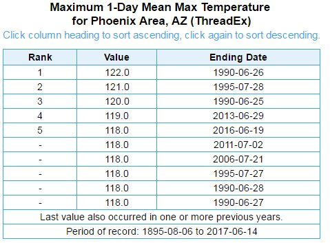
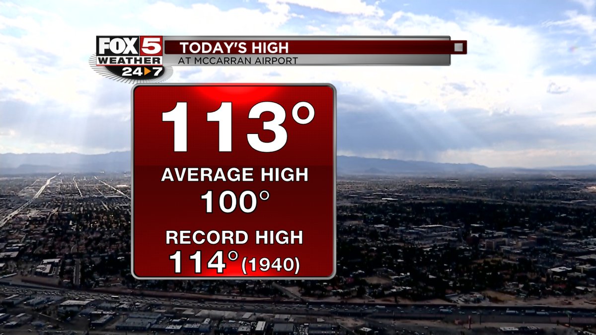
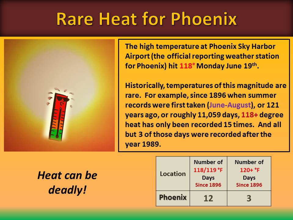
What about today? The parade of record reports is now coming in. Ouch! Phoenix got up to 118F and Vegas 113F:
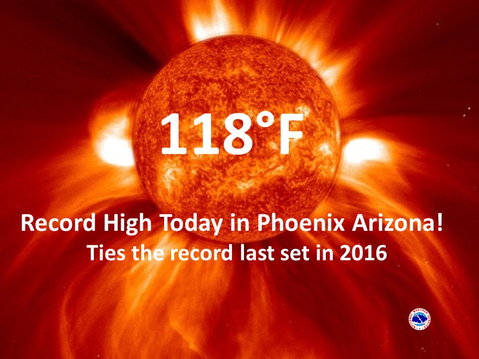
How rare was that reading of 118F at Phoenix? This graphic from the NWS tells the tale:
Both Phoenix bad Las Vegas should be a degree or two higher tomorrow.
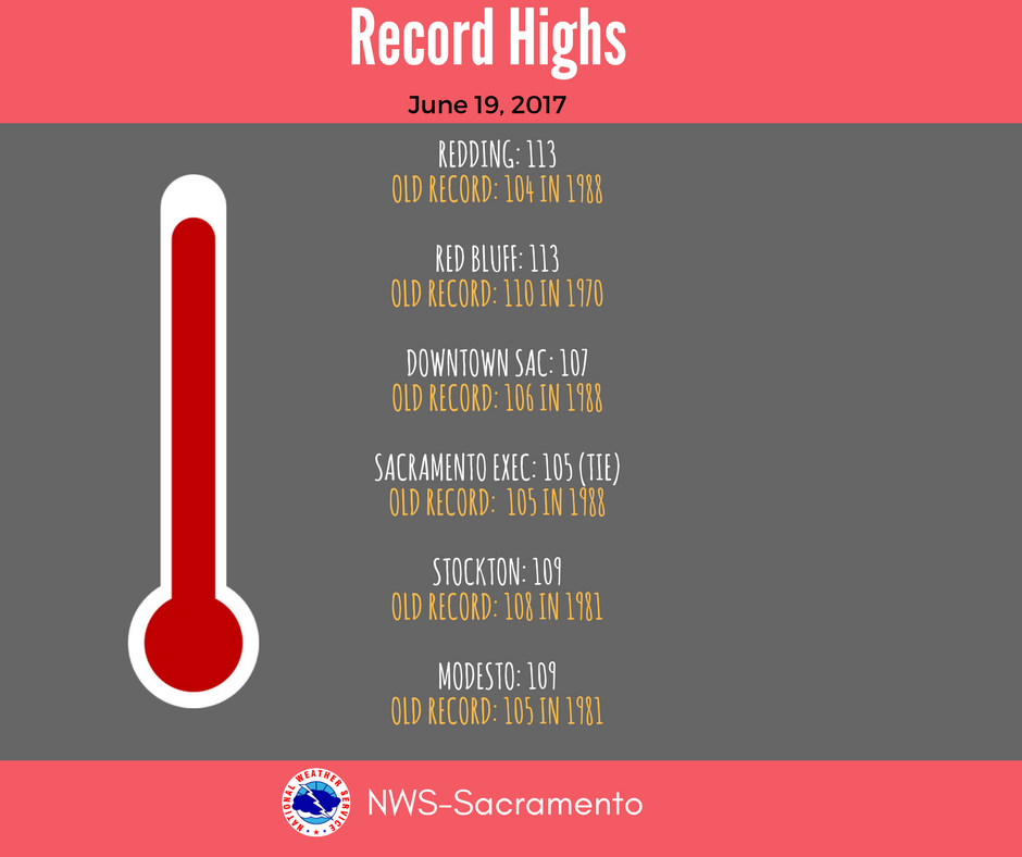
Record highs were being set at nearly every major station across the Sacramento Valley today:
Here are the rest of the nation’s maxes for Monday June 19th:
Thankfully, just like today, extreme heat will not be raging across the rest of the country through the end of the week as we move past the summer solstice.
The Climate Guy